


Data from smartphone apps and fitness trackers are helping planners to better understand park usage patterns and plan for new and improved parks.

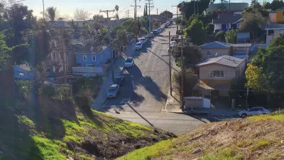
There is no question that the field of parks and recreation has become increasingly data-driven. The Los Angeles County Department of Parks and Recreation (DPR), for example, recently began to use data from fitness trackers and smartphone apps, among many other data sources, to help identify and analyze regional and rural park and recreation needs.
In this article, park planner Clement Lau discusses the 2022 L.A. Countywide Parks Needs Assessment Plus (PNA+) and how data collected from fitness apps and mobile phones helped park planners better understand park access, use, and visitorship. In addition to smartphone data, planners also employed the latest digital tools to collect, analyze, and visualize community input as part of the PNA+.
Adopted by the L.A. County Board of Supervisors in December 2022, the PNA+ Final Report presents data, maps, analyses, public input, and recommended actions which support additional land conservation and restoration, transit to parks, and other strategies to meet local and regional recreation needs, especially in the most vulnerable communities.
To learn more, please read the source article.
FULL STORY: How Cellphone and Fitness App Data is Helping Create Equity in Public Parks

Envisioning a New Park in East Los Angeles
Los Angeles County is working towards transforming underutilized land into a vibrant pocket park in the City Terrace neighborhood of East LA.

New Park Coming to Chinatown in Los Angeles
A new half-acre park is taking shape on a previously undeveloped hillside property in Chinatown, one of the more densely populated and park-poor areas in L.A.

Parks: Essential Community Infrastructure — and a Smart Investment
Even during times of budget constraint, continued investment in parks is critical, as they provide proven benefits to public health, safety, climate resilience, and community well-being — particularly for under-resourced communities.

Planetizen Federal Action Tracker
A weekly monitor of how Trump’s orders and actions are impacting planners and planning in America.

Restaurant Patios Were a Pandemic Win — Why Were They so Hard to Keep?
Social distancing requirements and changes in travel patterns prompted cities to pilot new uses for street and sidewalk space. Then it got complicated.

Map: Where Senate Republicans Want to Sell Your Public Lands
For public land advocates, the Senate Republicans’ proposal to sell millions of acres of public land in the West is “the biggest fight of their careers.”

Maui's Vacation Rental Debate Turns Ugly
Verbal attacks, misinformation campaigns and fistfights plague a high-stakes debate to convert thousands of vacation rentals into long-term housing.

San Francisco Suspends Traffic Calming Amidst Record Deaths
Citing “a challenging fiscal landscape,” the city will cease the program on the heels of 42 traffic deaths, including 24 pedestrians.

California Homeless Arrests, Citations Spike After Ruling
An investigation reveals that anti-homeless actions increased up to 500% after Grants Pass v. Johnson — even in cities claiming no policy change.
Urban Design for Planners 1: Software Tools
This six-course series explores essential urban design concepts using open source software and equips planners with the tools they need to participate fully in the urban design process.
Planning for Universal Design
Learn the tools for implementing Universal Design in planning regulations.
Heyer Gruel & Associates PA
JM Goldson LLC
Custer County Colorado
City of Camden Redevelopment Agency
City of Astoria
Transportation Research & Education Center (TREC) at Portland State University
Camden Redevelopment Agency
City of Claremont
Municipality of Princeton (NJ)