


The city’s new congestion pricing program, scheduled to take effect next year, could mean billions in new transit funding.
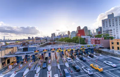
What will New York City’s congestion pricing program—now in its final planning stages—mean for public transit? As Stephen Nessen explains in Gothamist, the program is required by a 2019 state law to “bring in at least $1 billion a year for the MTA.”
Nessen adds, “The agency must use that money to finance $15 billion in bonds to pay for mass transit improvements included in its 2020-2024 capital plan — which was formed in the aftermath of New York City’s 2017 “summer of hell” when the subways and commuter railroads fell into disrepair.” The money will fund the expansion of the Second Avenue subway, the Penn Access project, and accessibility improvements at subway and Long Island Rail stations, as well as more electric buses. The article points out that congestion pricing revenue cannot legally be used for balancing the agency’s operating deficit, as some critics have claimed.
The next step is coming up with a price structure and exempt groups. Already, “Drivers won’t pay if they remain on the West Side Highway or FDR Drive south of 60th Street. Low-income drivers who live in the congestion zone, emergency vehicles and cars transporting people with disabilities are also exempt.” New Jersey officials say Garden State residents who commute to New York should receive discounted rates, although a 2021 analysis revealed that, of the 1.6 percent of New Jersey commuters who would likely pay the toll, most are more affluent than the average resident.
FULL STORY: MTA’s congestion pricing plan means big upgrades for NYC transit


Judge Extends NYC Congestion Pricing Through at Least June 9
A federal judge halted the Trump administration’s effort to kill the program, which remains in limbo as a lawsuit filed by the MTA moves forward.

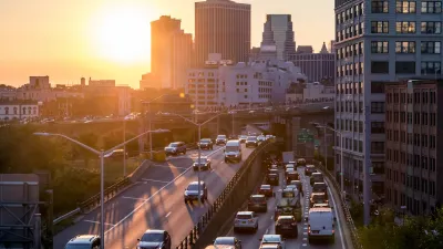
NYC Congestion Pricing Continues to Show Positive Results
While the Trump administration attempts to revoke the program’s federal approval, congestion pricing continues to reduce traffic, speed up bus travel times, and improve air quality in Manhattan.
USDOT Threatens to Pull New York Highway Funding
The Trump administration wants the state to kill New York City’s congestion pricing program despite its demonstrated success.

Planetizen Federal Action Tracker
A weekly monitor of how Trump’s orders and actions are impacting planners and planning in America.

Maui's Vacation Rental Debate Turns Ugly
Verbal attacks, misinformation campaigns and fistfights plague a high-stakes debate to convert thousands of vacation rentals into long-term housing.

San Francisco Suspends Traffic Calming Amidst Record Deaths
Citing “a challenging fiscal landscape,” the city will cease the program on the heels of 42 traffic deaths, including 24 pedestrians.

Amtrak Rolls Out New Orleans to Alabama “Mardi Gras” Train
The new service will operate morning and evening departures between Mobile and New Orleans.

The Subversive Car-Free Guide to Trump's Great American Road Trip
Car-free ways to access Chicagoland’s best tourist attractions.

San Antonio and Austin are Fusing Into one Massive Megaregion
The region spanning the two central Texas cities is growing fast, posing challenges for local infrastructure and water supplies.
Urban Design for Planners 1: Software Tools
This six-course series explores essential urban design concepts using open source software and equips planners with the tools they need to participate fully in the urban design process.
Planning for Universal Design
Learn the tools for implementing Universal Design in planning regulations.
Heyer Gruel & Associates PA
JM Goldson LLC
Custer County Colorado
City of Camden Redevelopment Agency
City of Astoria
Transportation Research & Education Center (TREC) at Portland State University
Jefferson Parish Government
Camden Redevelopment Agency
City of Claremont