


A new VR tool invites urban planners to viscerally understand how a small child experiences the urban realm—with less-than-ideal results.
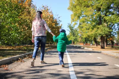
Won’t someone think of the children? Specifically, how do they see cities? As Nate Berg reports in Fast Company, a new VR tool aims to find out just that. “VR95 (as the name suggests) shrinks users to see a typical city scene from 95 centimeters, or three feet and one inch. This is the height of an average 3-year-old child.” The tool is designed to make city leaders, planners, and designers more aware of how children experience and use the built environment.
“The tool also shows what that same traffic-clogged city scene would look like if it was designed with that 3-year-old in mind. The sidewalks can be widened, pocket parks can be added, more green space can be planted, and car speeds can be reduced.” According to a guide developed by Arup and the Bernard van Leer Foundation called the Proximity of Care Design Guide, “Increasing access to nature, adding educational and play elements to public infrastructure, and engaging wider segments of the population in planning decisions are key ways cities can improve the lives of younger people.”
Far from just improving the experience of children, these changes would benefit all users of the public realm. Known as the ‘curb cut effect,’ this is the theory that designing for children, people with disabilities, or other vulnerable groups can improve cities for everyone. In Japan, where speed limits are low, curbside parking is rare, and streets are designed to force all modes to share the road, some neighborhoods are so safe that children as young as 2 or 3 can run errands on their own.
FULL STORY: This is how a 3-year-old sees a city—and it’s not very pleasant


How Urban Design Fails Families
For parents of small children, amenities like public restrooms or shady parks can vastly improve—or deteriorate—the experience of navigating cities.
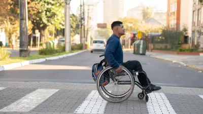
How to Protect Pedestrians With Disabilities
Public agencies don’t track traffic deaths and injuries involving disabled people, leaving a gap in data to guide safety interventions.

How Infrastructure Shapes Public Trust
A city engineer argues that planners must go beyond code compliance to ensure public infrastructure is truly accessible to all users.

Maui's Vacation Rental Debate Turns Ugly
Verbal attacks, misinformation campaigns and fistfights plague a high-stakes debate to convert thousands of vacation rentals into long-term housing.

Planetizen Federal Action Tracker
A weekly monitor of how Trump’s orders and actions are impacting planners and planning in America.

Chicago’s Ghost Rails
Just beneath the surface of the modern city lie the remnants of its expansive early 20th-century streetcar system.

Bend, Oregon Zoning Reforms Prioritize Small-Scale Housing
The city altered its zoning code to allow multi-family housing and eliminated parking mandates citywide.

Amtrak Cutting Jobs, Funding to High-Speed Rail
The agency plans to cut 10 percent of its workforce and has confirmed it will not fund new high-speed rail projects.

LA Denies Basic Services to Unhoused Residents
The city has repeatedly failed to respond to requests for trash pickup at encampment sites, and eliminated a program that provided mobile showers and toilets.
Urban Design for Planners 1: Software Tools
This six-course series explores essential urban design concepts using open source software and equips planners with the tools they need to participate fully in the urban design process.
Planning for Universal Design
Learn the tools for implementing Universal Design in planning regulations.
planning NEXT
Appalachian Highlands Housing Partners
Mpact (founded as Rail~Volution)
City of Camden Redevelopment Agency
City of Astoria
City of Portland
City of Laramie