


The Federal Highway Administration doesn’t analyze the condition of pavement on U.S. highways. If it did, it would find vast inequities depending on which communities live nearby highway infrastructure.
The U.S. Government Accountability Office (GAO) recently released research on the condition of pavement on the nation’s highways—finding that differences in pavement condition break down along income and racial lines.
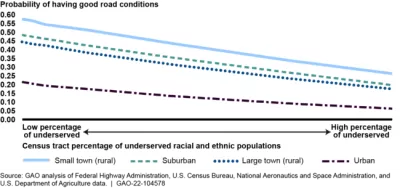
“Most of the pavement on our nation's highways—covering about 220,000 miles of roads—is in good or fair condition. But highway pavement is less likely to be in good condition in urban areas, localities with higher family poverty rates, and areas with higher percentages of underserved racial and ethnic populations,” according to the website that shares the data.
The website also calls on the Federal Highway Administration to routinely examine state data on pavement conditions to better address inequities in pavement conditions.
“The National Highway System is key to the nation's economy, defense, and mobility. It comprises approximately 220,000 miles of roads and accounts for about 54 percent of all vehicle miles traveled. Poor pavement condition on National Highway System roads could pose safety issues and impede the flow of traffic,” according to the GAO.
At the local level, the city of Oakland, California made news a few years ago by focusing road repair and reconfiguration work in underserved neighborhoods, recognizing the effects of inequity in maintenance work over the years.
FULL STORY: Analysis of Available Data Could Better Ensure Equitable Pavement Condition

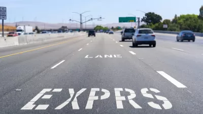
Congestion Pricing in the San Francisco Bay Area
Planners call them “express lanes,” but make no mistake, they are congestion pricing in action, and they're successful. The Bay Area network of what the Federal Highway Administration calls “high-occupancy toll (HOT) lanes” is growing.

Report: Federal Policies to Make Traffic Enforcement More Equitable
Recommendations for how USDOT can guide more equitable traffic enforcement that improves traffic safety and protects vulnerable populations.

Study Assesses Attitudes on Traffic Cameras in Boston’s Black Communities
Residents are wary of the new technology’s potential for surveillance, but support boosting enforcement while reducing interaction with police.

Planetizen Federal Action Tracker
A weekly monitor of how Trump’s orders and actions are impacting planners and planning in America.

Chicago’s Ghost Rails
Just beneath the surface of the modern city lie the remnants of its expansive early 20th-century streetcar system.

San Antonio and Austin are Fusing Into one Massive Megaregion
The region spanning the two central Texas cities is growing fast, posing challenges for local infrastructure and water supplies.

Since Zion's Shuttles Went Electric “The Smog is Gone”
Visitors to Zion National Park can enjoy the canyon via the nation’s first fully electric park shuttle system.

Trump Distributing DOT Safety Funds at 1/10 Rate of Biden
Funds for Safe Streets and other transportation safety and equity programs are being held up by administrative reviews and conflicts with the Trump administration’s priorities.

German Cities Subsidize Taxis for Women Amid Wave of Violence
Free or low-cost taxi rides can help women navigate cities more safely, but critics say the programs don't address the root causes of violence against women.
Urban Design for Planners 1: Software Tools
This six-course series explores essential urban design concepts using open source software and equips planners with the tools they need to participate fully in the urban design process.
Planning for Universal Design
Learn the tools for implementing Universal Design in planning regulations.
planning NEXT
Appalachian Highlands Housing Partners
Mpact (founded as Rail~Volution)
City of Camden Redevelopment Agency
City of Astoria
City of Portland
City of Laramie