


The beautiful new park is much needed in Chinatown, one of the more densely populated and park-poor areas in L.A.
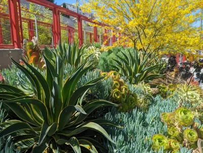
According to the 2016 Los Angeles Countywide Parks Needs Assessment, Chinatown is located in a study area with a high level of park need. The area only had 1.6 acres of parkland per 1,000 residents, which was substantially below the Countywide average of 3.3 acres per 1,000 residents. Thus, it is great news that Chinatown now has a beautiful new public space called Ord and Yale Street Park.
As landscape architect Wendy Chan shares in this article, the park was designed by the landscape architecture and planning firm AHBE/MIG, and represents the transformation of a once-vacant, one-acre hillside into a new neighborhood park for Chinatown residents, many of whom live in dense apartment complexes. Located directly behind the Chinatown Branch Library, the site has a steep elevation change of over 100 feet from the entry to the top of the park.
To learn more about the park and its design, please read the source article.
FULL STORY: Cultural Connection: A Chinatown park aims to link residents to their neighborhood


Parks: Essential Community Infrastructure — and a Smart Investment
Even during times of budget constraint, continued investment in parks is critical, as they provide proven benefits to public health, safety, climate resilience, and community well-being — particularly for under-resourced communities.

Palmdale’s Beloved Water Park Gets $2 Million Upgrade
To mark its 20th anniversary, DryTown Water Park has undergone major renovations, ensuring that families across the Antelope Valley continue to enjoy safe, affordable, and much-needed water-based recreation in the high desert.
Irvine Ranked Second in Nation for Outstanding Park System
Irvine’s parks earned national recognition for their exceptional access, investment, and amenities, ranking second in the U.S. and first in California in the Trust for Public Land’s 2025 ParkScore Index.

Planetizen Federal Action Tracker
A weekly monitor of how Trump’s orders and actions are impacting planners and planning in America.

Map: Where Senate Republicans Want to Sell Your Public Lands
For public land advocates, the Senate Republicans’ proposal to sell millions of acres of public land in the West is “the biggest fight of their careers.”

Restaurant Patios Were a Pandemic Win — Why Were They so Hard to Keep?
Social distancing requirements and changes in travel patterns prompted cities to pilot new uses for street and sidewalk space. Then it got complicated.

Platform Pilsner: Vancouver Transit Agency Releases... a Beer?
TransLink will receive a portion of every sale of the four-pack.

Toronto Weighs Cheaper Transit, Parking Hikes for Major Events
Special event rates would take effect during large festivals, sports games and concerts to ‘discourage driving, manage congestion and free up space for transit.”

Berlin to Consider Car-Free Zone Larger Than Manhattan
The area bound by the 22-mile Ringbahn would still allow 12 uses of a private automobile per year per person, and several other exemptions.
Urban Design for Planners 1: Software Tools
This six-course series explores essential urban design concepts using open source software and equips planners with the tools they need to participate fully in the urban design process.
Planning for Universal Design
Learn the tools for implementing Universal Design in planning regulations.
Heyer Gruel & Associates PA
JM Goldson LLC
Custer County Colorado
City of Camden Redevelopment Agency
City of Astoria
Transportation Research & Education Center (TREC) at Portland State University
Camden Redevelopment Agency
City of Claremont
Municipality of Princeton (NJ)