


As more urban surfaces are developed and covered with impermeable materials, the importance of green infrastructure like bioswales and permeable pavement is growing.
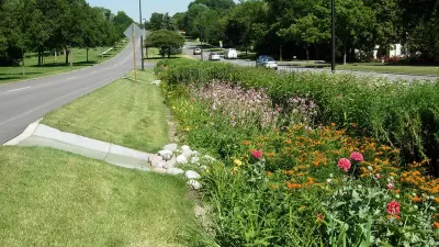
According to an article by Shaun McGillis, “In cities across the US, roads, rooftops, parking lots, sidewalks and driveways increased by an average of 326,000 hectares per year between 2012 and 2017.” These impermeable surfaces raise flood risks, but “The introduction of green infrastructures (GI), such as bioswales with permeable surfaces, has provided municipalities with a new tool to manage flood risk associated with rainfall.”
A new study from Portland State University analyzed the distribution of GI in three cities to evaluate whether it is distributed equitably.
According to the paper's lead author, Arun Pallathadka, a Ph.D. student in the Earth, Environment and Society program at Portland State, the research team found that the placement of GI in each of the cities inconsistently overlapped with areas prone to rainwater flooding, and non-white and low-income populations were more vulnerable to flood risk. Portland and Phoenix have increased investments in GI in neighborhoods with higher populations of non-white and low-income residents, marking a transition to more equitable flood risk management. In Atlanta, the risk of rainwater flooding was relatively low for non-white and low-income residents, though there was a substantial disparity in GI coverage.
As McGillis writes, “The methods deployed by the team provide cities with a novel approach to assessing the need for GI in neighborhoods prone to flooding associated with rainwater while also planning for the equitable distribution of those resources as they move ahead under the threat of increasing extreme precipitation events associated with a warming planet.”
FULL STORY: Rain, floods and green infrastructure: are cities mitigating the hazards equitably?

Grassroots Dutch Movement Replaces Pavement With Green Space
Neighbors engage in a practice known as “tegelwippen,” picking up paving stones and replacing them with permeable surfaces, often with the support of local governments.
Flood Resilience Through Green Infrastructure
Cities like New York and Los Angeles are moving to build green infrastructure as the need for spongier urban spaces becomes more apparent.
Designing Permeable Cities for Drought Resilience
Take a kayak trip on the Los Angeles River with KQED science reporter Amy Standen to understand why cities were built on the premise of endless potable water and how we can build cities sustainably in regions that receive low rainfall.

Planetizen Federal Action Tracker
A weekly monitor of how Trump’s orders and actions are impacting planners and planning in America.

Map: Where Senate Republicans Want to Sell Your Public Lands
For public land advocates, the Senate Republicans’ proposal to sell millions of acres of public land in the West is “the biggest fight of their careers.”

Restaurant Patios Were a Pandemic Win — Why Were They so Hard to Keep?
Social distancing requirements and changes in travel patterns prompted cities to pilot new uses for street and sidewalk space. Then it got complicated.

Platform Pilsner: Vancouver Transit Agency Releases... a Beer?
TransLink will receive a portion of every sale of the four-pack.

Toronto Weighs Cheaper Transit, Parking Hikes for Major Events
Special event rates would take effect during large festivals, sports games and concerts to ‘discourage driving, manage congestion and free up space for transit.”

Berlin to Consider Car-Free Zone Larger Than Manhattan
The area bound by the 22-mile Ringbahn would still allow 12 uses of a private automobile per year per person, and several other exemptions.
Urban Design for Planners 1: Software Tools
This six-course series explores essential urban design concepts using open source software and equips planners with the tools they need to participate fully in the urban design process.
Planning for Universal Design
Learn the tools for implementing Universal Design in planning regulations.
Heyer Gruel & Associates PA
JM Goldson LLC
Custer County Colorado
City of Camden Redevelopment Agency
City of Astoria
Transportation Research & Education Center (TREC) at Portland State University
Camden Redevelopment Agency
City of Claremont
Municipality of Princeton (NJ)