


City and state officials hope the proposal to turn part of I-375 into a walkable boulevard will help bring back businesses and economic vitality to the area.
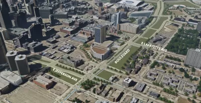
A one-mile stretch of Interstate 375 in Detroit could become a "livable, walkable, rideable" boulevard that accommodates pedestrians, cyclists, and other road users. Eli Newman reports on a plan being formed by the state and the city to reconnect the neighborhood that the interstate sliced through decades ago.
"Construction on I-375 started in 1959, displacing African-American businesses and residential life in Black Bottom and Paradise Valley. [Michigan Governor Gretchen] Whitmer says there is 'a sad history' behind the construction of the freeway, which had 'devastating impacts.' The boulevard project could unify the surrounding areas today." The article points out that "According to the Detroit Historical Society, there were more than 300 Black-owned businesses in the district during the 1920s, when many African American migrants from the South came to the near east neighborhoods."
Transforming the freeway to a boulevard could "improve walkability and re-establish business along the corridor," according to Detroit mayor Mike Duggan. "Duggan says the I-375 project could resemble recent streetscape restoration in Detroit like the “Avenue of Fashion” section of Livernois. He says there would need to be a combined city and state authority that oversees the development."
The Michigan Department of Transportation (MDOT) anticipates construction could begin in 2027 and last three years, notes Newman. "The state is holding community meetings to discuss design plans following initial approval from the federal government."
FULL STORY: Plans to turn I-375 in downtown Detroit into a boulevard move forward


Dead End: Nine Highways Ready for Retirement
The Freeways Without Futures report describes the nation’s most promising highway removal proposals.

Bridging Divides: The Crucial Role of Collaboration in Highway Removal
Highway removal is most successful when agencies at all levels of government work closely with each other and the impacted community.
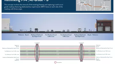
More Options Presented for Minneapolis I-94 Project
Two new proposals for replacing the freeway with at-grade segments offer new visions for the future of downtown Minneapolis.

Maui's Vacation Rental Debate Turns Ugly
Verbal attacks, misinformation campaigns and fistfights plague a high-stakes debate to convert thousands of vacation rentals into long-term housing.

Planetizen Federal Action Tracker
A weekly monitor of how Trump’s orders and actions are impacting planners and planning in America.

In Urban Planning, AI Prompting Could be the New Design Thinking
Creativity has long been key to great urban design. What if we see AI as our new creative partner?

King County Supportive Housing Program Offers Hope for Unhoused Residents
The county is taking a ‘Housing First’ approach that prioritizes getting people into housing, then offering wraparound supportive services.

Researchers Use AI to Get Clearer Picture of US Housing
Analysts are using artificial intelligence to supercharge their research by allowing them to comb through data faster. Though these AI tools can be error prone, they save time and housing researchers are optimistic about the future.

Making Shared Micromobility More Inclusive
Cities and shared mobility system operators can do more to include people with disabilities in planning and operations, per a new report.
Urban Design for Planners 1: Software Tools
This six-course series explores essential urban design concepts using open source software and equips planners with the tools they need to participate fully in the urban design process.
Planning for Universal Design
Learn the tools for implementing Universal Design in planning regulations.
planning NEXT
Appalachian Highlands Housing Partners
Mpact (founded as Rail~Volution)
City of Camden Redevelopment Agency
City of Astoria
City of Portland
City of Laramie