


Urban designers are playing the advocate in a Michigan Department of Transportation study that is considering ways to reconfigure U.S. Highway 131 where it curves through Downtown Grand Rapids.
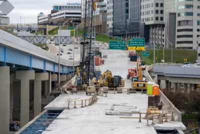
The Michigan Department of Transportation is seeking public feedback on a potential redesign of U.S. Highway 131 in Grand Rapids.
"The state’s fiscal year budget that began Oct. 1 included $10 million to study the reconstruction or reconfiguration of the Wealthy Street interchange that has been referred to as the most dangerous intersection in the state," reports Kate Carlson for MiBiz.
The route is heavily used for goods movement and freight for large industrial uses, but some local advocates monitoring the US-131 Planning and Environmental Linkages (PEL) Study say that safety should be a larger concern in the redesign. The Wealthy Street interchange, for example, is at the southern end of the highway's S-curve through downtown Grand Rapids.
"The concept of redesigning the area surrounding the S-curve dates back decades, with some supporting a redesign that puts the stretch of US-131 at grade, potentially rerouting freight traffic to I-196," explains Carlson.
Soundbites from Ted Lott, principal with Lott3Metz Architecture LLC, and Tim Mroz, vice president of strategic initiatives at The Right Place Inc., are included in the source article.
FULL STORY: MDOT study of U.S. 131 to balance industrial, placemaking concerns

‘Safe Land Use:’ A Key to Road Safety
How approaching transportation planning through a public health lens can reduce traffic deaths.

Olympia Draft Transportation Plan Zeroes in on Complete Streets, Bike Infrastructure
The city’s comprehensive plan update could signal a shift in transportation planning priorities to a more comprehensive approach that ensures safer roads for all users.
California Transportation Commission Reluctant to Incorporate Complete Streets Guidelines
The agency plans to update its road design guidelines by the end of the year — before a new law that prioritizes pedestrian and cyclist safety takes effect.

Planetizen Federal Action Tracker
A weekly monitor of how Trump’s orders and actions are impacting planners and planning in America.

Chicago’s Ghost Rails
Just beneath the surface of the modern city lie the remnants of its expansive early 20th-century streetcar system.

San Antonio and Austin are Fusing Into one Massive Megaregion
The region spanning the two central Texas cities is growing fast, posing challenges for local infrastructure and water supplies.

Since Zion's Shuttles Went Electric “The Smog is Gone”
Visitors to Zion National Park can enjoy the canyon via the nation’s first fully electric park shuttle system.

Trump Distributing DOT Safety Funds at 1/10 Rate of Biden
Funds for Safe Streets and other transportation safety and equity programs are being held up by administrative reviews and conflicts with the Trump administration’s priorities.

German Cities Subsidize Taxis for Women Amid Wave of Violence
Free or low-cost taxi rides can help women navigate cities more safely, but critics say the programs don't address the root causes of violence against women.
Urban Design for Planners 1: Software Tools
This six-course series explores essential urban design concepts using open source software and equips planners with the tools they need to participate fully in the urban design process.
Planning for Universal Design
Learn the tools for implementing Universal Design in planning regulations.
planning NEXT
Appalachian Highlands Housing Partners
Mpact (founded as Rail~Volution)
City of Camden Redevelopment Agency
City of Astoria
City of Portland
City of Laramie