


Among the options on the table for the Southside Complete Streets Project is a configuration that would turn Telegraph Avenue near the campus of UC Berkeley into a pedestrian, bike, and transit-only plaza.
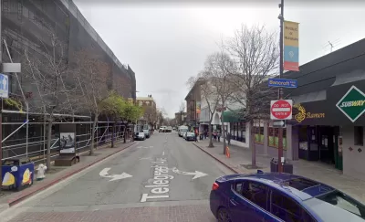
The blocks of Telegraph Avenue nearest to the campus of the University of California, Berkeley could soon be reconfigured to block cars, raise the street to the level of its sidewalks, and create transit bus lanes and improved pedestrian and bike infrastructure, reports Katie Lauer for the Mercury News in an article that might be paywalled for some readers.
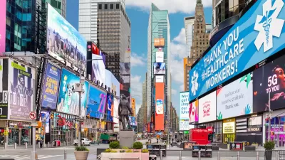
The Southside Complete Streets Project aspires to create a "Times Square of the West" along the bustling corridor, which currently achieves its vibrancy despite one-way car traffic than ends when the street meets the campus near Sproul Plaza and Sather Gate.
According to Lauer, "the redesign will feature dedicated bus lanes, protected bike paths, widened sidewalks, improved pedestrian crossings and public transit stops. The purpose is to reduce dangerous traffic collisions, improve local transit reliability and boost the economic and cultural vitality of the neighborhood..."
The car-free plan is one alternative in the project, which is still under study after receiving a preliminary green light from the Berkeley City Council.
"Although the car-free idea wasn’t originally on the table, city officials bought into it following public outreach last summer and a last-minute push by members of Telegraph for People, a student-driven advocacy group," reports Lauer.
More details on the various options on the table for the project, including street cross sections, are included in the source article below.
FULL STORY: Berkeley: Plan may turn Telegraph Avenue into ‘West Coast’s Times Square’


Paris Voters Approve More Car-Free Streets
Paris Mayor Anne Hidalgo says the city will develop a plan to close 500 streets to car traffic and add new bike and pedestrian infrastructure after a referendum on the proposal passed with 66 percent of the vote.
NYC Officials Announce Broadway Pedestrianization Project
Two blocks of the marquee street will become mostly car-free public spaces.

Meet NYC’s New Office of Livable Streets
The NYC DOT program will build on pandemic-era initiatives to promote safe and comfortable streets that enhance community and expand uses beyond just moving cars.

Maui's Vacation Rental Debate Turns Ugly
Verbal attacks, misinformation campaigns and fistfights plague a high-stakes debate to convert thousands of vacation rentals into long-term housing.

Planetizen Federal Action Tracker
A weekly monitor of how Trump’s orders and actions are impacting planners and planning in America.

Chicago’s Ghost Rails
Just beneath the surface of the modern city lie the remnants of its expansive early 20th-century streetcar system.

Bend, Oregon Zoning Reforms Prioritize Small-Scale Housing
The city altered its zoning code to allow multi-family housing and eliminated parking mandates citywide.

Amtrak Cutting Jobs, Funding to High-Speed Rail
The agency plans to cut 10 percent of its workforce and has confirmed it will not fund new high-speed rail projects.

LA Denies Basic Services to Unhoused Residents
The city has repeatedly failed to respond to requests for trash pickup at encampment sites, and eliminated a program that provided mobile showers and toilets.
Urban Design for Planners 1: Software Tools
This six-course series explores essential urban design concepts using open source software and equips planners with the tools they need to participate fully in the urban design process.
Planning for Universal Design
Learn the tools for implementing Universal Design in planning regulations.
planning NEXT
Appalachian Highlands Housing Partners
Mpact (founded as Rail~Volution)
City of Camden Redevelopment Agency
City of Astoria
City of Portland
City of Laramie