


New research suggests that fewer speeding tickets are issued in neighborhoods where the city has invested in traffic calming and pedestrian safety improvements.
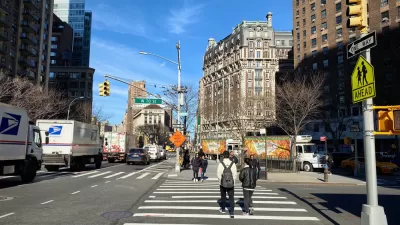
A study from New York City indicates that, while automated traffic enforcement cameras are evenly distributed across the city's neighborhoods, safe roadways and pedestrian infrastructure are not. As Julianne Cuba and Brian Howald report, "A new map created by activist Brian Howald shows where in the city drivers are getting nabbed for speeding in school zones and blowing through red lights, revealing a pattern of inequity not based on the location of the cameras themselves, but where the city has failed to provide adequate infrastructure that protects vulnerable road users."
Yes, the cameras are evenly distributed geographically in the city, but many tickets are issued in many communities of color because of the wide, speedway-like arterials that cut through such neighborhoods, and which have not been redesigned by the city for safety as they have been in White neighborhoods. The result is not only many speeding tickets written in communities of color, but also that residents of those neighborhoods are disproportionately the victims of road violence, advocates say.
This sheds light on the controversial devices and the argument over whether they unfairly target particular communities, signaling that, as pointed out in a recent ProPublica article, infrastructure—such as wide streets that encourage speeding—matters when it comes to driver behavior and road safety. Cuba and Howald's article quotes lawmakers and activists who want to see automated enforcement coupled with investment in safer roadways. "Such senseless deaths unfortunately happen far too often in our city, but they can be easily prevented with investment in more protective pedestrian and bicycle infrastructure," wrote state Senator Julia Salazar last year.
FULL STORY: Are Speed Cameras Racist?

Philly Speed Camera Program Cuts Fatalities in Half
Excessive speeding along dangerous segments of Roosevelt Boulevard dropped by 90 percent after the city installed automated enforcement cameras.
Chicago Traffic Cameras Issue Most Tickets to Black and Latino Drivers
The city's controversial traffic camera program tickets Black and Latino motorists more than white drivers. Infrastructure may play a role in why.

In N.Y.C., Speeding Is Up as Pandemic Continues
Data shows that drivers are speeding on the city’s mostly deserted streets.

Maui's Vacation Rental Debate Turns Ugly
Verbal attacks, misinformation campaigns and fistfights plague a high-stakes debate to convert thousands of vacation rentals into long-term housing.

Planetizen Federal Action Tracker
A weekly monitor of how Trump’s orders and actions are impacting planners and planning in America.

In Urban Planning, AI Prompting Could be the New Design Thinking
Creativity has long been key to great urban design. What if we see AI as our new creative partner?

King County Supportive Housing Program Offers Hope for Unhoused Residents
The county is taking a ‘Housing First’ approach that prioritizes getting people into housing, then offering wraparound supportive services.

Researchers Use AI to Get Clearer Picture of US Housing
Analysts are using artificial intelligence to supercharge their research by allowing them to comb through data faster. Though these AI tools can be error prone, they save time and housing researchers are optimistic about the future.

Making Shared Micromobility More Inclusive
Cities and shared mobility system operators can do more to include people with disabilities in planning and operations, per a new report.
Urban Design for Planners 1: Software Tools
This six-course series explores essential urban design concepts using open source software and equips planners with the tools they need to participate fully in the urban design process.
Planning for Universal Design
Learn the tools for implementing Universal Design in planning regulations.
planning NEXT
Appalachian Highlands Housing Partners
Mpact (founded as Rail~Volution)
City of Camden Redevelopment Agency
City of Astoria
City of Portland
City of Laramie