


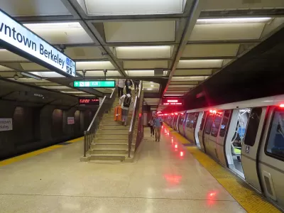
Berkeley planning commissioners recommend taller buildings, more density as the city evaluates zoning changes near BART stations.
Emilie Raguso reports on a Berkeley Planning Commission meeting that had at its center a proposal to develop housing on parking lots at two BART stations. At issue during Wednesday's meeting were proposed height limits and the percentage of affordable housing that would be required.
On Wednesday, there were two clear camps among the callers: Those pushing for a higher percentage of affordable units in, primarily, somewhat shorter projects overseen by nonprofit developers and those asserting that the best way to get the highest number of affordable units is to build taller buildings.
While some community members called for a maximum height of seven stories, many Commissioners expressed support for taller buildings of up to 12 stories to accommodate more housing units. Raguso quotes Commissioner Barnali Ghosh as saying, "We have to start making sacrifices here. But I also don’t think of density as a sacrifice."
The proposal for the BART sites and related zoning changes will undergo further consideration by the Berkeley City Council in early 2022. The discussion comes after the council voted to eliminate single-family zoning and minimum parking requirements, reversals on decades-old policies that city leaders hope will help alleviate Berkeley's deepening housing affordability crisis, encourage public transit use, and reduce carbon emissions.
FULL STORY: Planning Commission on BART housing: 7 stories is not enough


Editorial Exposes Bay Area Housing Hypocrisy
Cities can't have it both ways on the housing crisis, asserts an SF Chronicle editorial. Case in point: Berkeley passes a resolution to declare homelessness a state of emergency while opposing legislation to allow BART to develop its parking lots.
High Housing Costs Driving Down Transit Ridership in LA
When neighborhoods gentrify and displace lower-income residents, transit ridership suffers, new research shows.

Massachusetts TOD Law Yielding Results
While some cities are fighting the state’s push to increase density near transit, others are already breaking ground on multifamily projects that will bring hundreds of new housing units online.

Maui's Vacation Rental Debate Turns Ugly
Verbal attacks, misinformation campaigns and fistfights plague a high-stakes debate to convert thousands of vacation rentals into long-term housing.

Planetizen Federal Action Tracker
A weekly monitor of how Trump’s orders and actions are impacting planners and planning in America.

San Francisco Suspends Traffic Calming Amidst Record Deaths
Citing “a challenging fiscal landscape,” the city will cease the program on the heels of 42 traffic deaths, including 24 pedestrians.

Defunct Pittsburgh Power Plant to Become Residential Tower
A decommissioned steam heat plant will be redeveloped into almost 100 affordable housing units.

Trump Prompts Restructuring of Transportation Research Board in “Unprecedented Overreach”
The TRB has eliminated more than half of its committees including those focused on climate, equity, and cities.

Amtrak Rolls Out New Orleans to Alabama “Mardi Gras” Train
The new service will operate morning and evening departures between Mobile and New Orleans.
Urban Design for Planners 1: Software Tools
This six-course series explores essential urban design concepts using open source software and equips planners with the tools they need to participate fully in the urban design process.
Planning for Universal Design
Learn the tools for implementing Universal Design in planning regulations.
Heyer Gruel & Associates PA
JM Goldson LLC
Custer County Colorado
City of Camden Redevelopment Agency
City of Astoria
Transportation Research & Education Center (TREC) at Portland State University
Jefferson Parish Government
Camden Redevelopment Agency
City of Claremont