


New research shows a 24% increase in people living in flood-prone areas since 2000, prompting calls for increased adaptation measures.
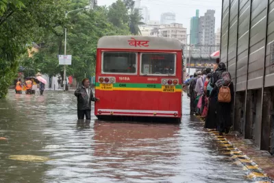
As urban centers around the world grow, sea levels rise, and extreme weather becomes more common, "the proportion of the world’s population living in flood zones has increased exponentially," writes Linda Poon. According to new research published in the journal Nature, "[f]rom 2000 to 2015, the number of people living in flood-prone areas increased by an estimated 58 million to 86 million," a 24% increase.
"The study uses a trove of satellite imagery to map 913 major flood events since 2000, which the flood monitoring startup Cloud to Street says offers planners a more detailed scope than flood projection models of the crisis facing cities." The resulting maps "combine flooding imagery with global human settlement data to show population growth in flooded areas, which the researchers attribute to increased economic development and migration to flood zones."
"Nearly 90% of the floods analyzed occurred in South and Southeast Asia, with high flood exposure in areas that have large river basins and that saw large population growth, like Dhaka and Bangladesh. In 32 countries across four continents, the population exposed to flood is increasing at a rate higher than total population growth, with India and some countries in Africa experiencing particularly large increases in flood exposure."
Flooding also poses a risk to basic infrastructure. "From the recent flooding of New York City’s nearly 120-year-old subway to Zhengzhou’s metro system in China’s Henan province, much of the urban infrastructure built decades ago is not designed to handle the kind of historic rainfall that cities often see today."
The researchers are making the database public "to help policymakers improve the accuracy of global flood risk models, which can be rife with uncertainties," and "improve the quality of vulnerability assessments, which in turn can increase the efficacy of climate adaptation measures."
FULL STORY: More People Live in Flood Zones Than Previously Thought

As Development in Flood-Prone Areas Continues, Cities Are Slow to Respond
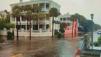
Drawn by affordable property, low taxes, and job opportunities, high numbers of Americans continue to move to flood-prone areas even as the threat of catastrophic flooding grows.

Rising Above: Innovative Solutions for Waikīkī’s Sea-Level Challenges
The University of Hawaiʻi at Mānoa’s award-winning Waikīkī sea-level rise adaptation project combines science, architecture, and community input to create scalable solutions for climate resilience and coastal flood mitigation.
How US Cities Can Prepare for Climate Disasters
Resilience, encompassing infrastructure, governance, economic strength, and social cohesion, is critical for cities to mitigate rising climate risks like flooding, wildfires, and heat, ensuring long-term recovery and adaptability.

Planetizen Federal Action Tracker
A weekly monitor of how Trump’s orders and actions are impacting planners and planning in America.

Restaurant Patios Were a Pandemic Win — Why Were They so Hard to Keep?
Social distancing requirements and changes in travel patterns prompted cities to pilot new uses for street and sidewalk space. Then it got complicated.

Map: Where Senate Republicans Want to Sell Your Public Lands
For public land advocates, the Senate Republicans’ proposal to sell millions of acres of public land in the West is “the biggest fight of their careers.”

Maui's Vacation Rental Debate Turns Ugly
Verbal attacks, misinformation campaigns and fistfights plague a high-stakes debate to convert thousands of vacation rentals into long-term housing.

San Francisco Suspends Traffic Calming Amidst Record Deaths
Citing “a challenging fiscal landscape,” the city will cease the program on the heels of 42 traffic deaths, including 24 pedestrians.

California Homeless Arrests, Citations Spike After Ruling
An investigation reveals that anti-homeless actions increased up to 500% after Grants Pass v. Johnson — even in cities claiming no policy change.
Urban Design for Planners 1: Software Tools
This six-course series explores essential urban design concepts using open source software and equips planners with the tools they need to participate fully in the urban design process.
Planning for Universal Design
Learn the tools for implementing Universal Design in planning regulations.
Heyer Gruel & Associates PA
JM Goldson LLC
Custer County Colorado
City of Camden Redevelopment Agency
City of Astoria
Transportation Research & Education Center (TREC) at Portland State University
Camden Redevelopment Agency
City of Claremont
Municipality of Princeton (NJ)