


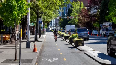
By prioritizing a multi-modal approach and preserving existing vehicle space, the Seattle Department of Transportation risks abandoning the goals of its bicycle master plan.
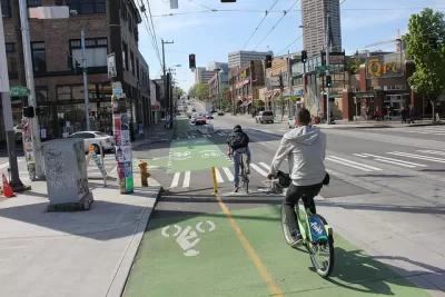
The Seattle Department of Transportation (SDOT) is defending the decision to eliminate planned bike lanes on 35th Ave NE, arguing that removing the dedicated bicycle space will allow for more efficient transit movement through the area. SDOT Director Sam Zimbabwe blamed "outdated" modal plans that don't "play nice" with each other. The agency is developing a new framework for resolving conflicts between modes, but it's unclear where and how bike infrastructure will be prioritized.
So far, the proposed policy prioritizes pedestrians in "urban centers and villages," transit between neighborhoods, and goods movement in industrial centers. The bicycle network will receive priority "at critical connections" where it will "share priority with pedestrians," signaling support for multi-use paths and trails rather than dedicated bike lanes.
"From what I have seen, it’s mostly a way of preserving the status quo," said Anna Zivarts, a pedestrian advisory board representative on SDOT's Policy and Operations Advisory Group (POAG). Bryce Kolton, a representative from POAG's transit advisory board, echoed similar concerns, citing a reluctance on the part of the city to redistribute street space away from single occupancy vehicles. "Until they can tell me why established plans have not been completed when they aren’t for car traffic … I don’t think a multi-multimodal plan is the answer."
Ryan Packer, writing for Seattle Bike Blog, acknowledges that there are still a lot of questions about how a more multi-modal transportation plan will affect bike infrastructure, but with almost no space reallocated from vehicles to bicycles, the "skeletal" policies proposed within the new framework seem to walk back the more ambitious goals of the past.
FULL STORY: The end of the Bicycle Master Plan as we know it?


Seattle Neighborhood Groups Propose Aerial Gondola to Replace Light Rail Expansion
Impatient with the city's light rail expansion plans, some residents are looking to aerial gondolas as a new mode of public transit.
Seattle Planning Commission Urges Reimagining of the City’s Streets
In a set of recommendations submitted to the city, the commission calls for revised land use and transportation policies that reclaim public space from cars and shift focus away from vehicle throughput to more pedestrian-oriented uses.

Rochester to Update Bicycle Master Plan with More Multimodal Infrastructure
The new active transportation plan will amend the existing bicycle master plan to include additional safety improvements for pedestrians and other multimodal road users.

Planetizen Federal Action Tracker
A weekly monitor of how Trump’s orders and actions are impacting planners and planning in America.

Maui's Vacation Rental Debate Turns Ugly
Verbal attacks, misinformation campaigns and fistfights plague a high-stakes debate to convert thousands of vacation rentals into long-term housing.

Cuomo Is the Candidate of Both NIMBYs and Developers. What Gives?
In the New York City mayoral race, odd bedfellows align to preserve the housing status quo.

The Subversive Car-Free Guide to Trump's Great American Road Trip
Car-free ways to access Chicagoland’s best tourist attractions.

San Antonio and Austin are Fusing Into one Massive Megaregion
The region spanning the two central Texas cities is growing fast, posing challenges for local infrastructure and water supplies.

Charlottesville Temporarily Has No Zoning Code
A judge ordered the Virginia city to throw out its newly revised zoning code, leaving permitting for new development in legal limbo.
Urban Design for Planners 1: Software Tools
This six-course series explores essential urban design concepts using open source software and equips planners with the tools they need to participate fully in the urban design process.
Planning for Universal Design
Learn the tools for implementing Universal Design in planning regulations.
Heyer Gruel & Associates PA
JM Goldson LLC
Custer County Colorado
City of Camden Redevelopment Agency
City of Astoria
Transportation Research & Education Center (TREC) at Portland State University
Jefferson Parish Government
Camden Redevelopment Agency
City of Claremont