


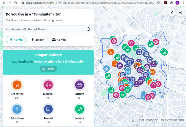
The new 15-Minute City App generates maps which show the number of services and activities within a 15 minute walk, and and therefore whether an area can be considered a 15-minute neighborhood.
A 15-min city, or “la ville du quart d’heure” refers to an urban neighborhood where all the essential needs can be accessed within a 15 minute walk or bike ride. This is a practical way to evaluate multi-modal accessibility, that is, the ease of living without a car, and therefore whether a neighborhood is affordable, equitable, healthy and resource-efficient.
The new 15-Minute City App generates maps for U.S. addresses which show the number of medical centers, grocery stores, cultural attractions, transit stops, education facilities and leisure spots that can be reached within a 15 or 20 minute walk, and therefore whether it can be considered to be in a 15-minute neighborhood.
Real estate agents and developers pay attention: consumer preference surveys indicate that most households want to live in walkable neighborhoods, resulting in a shortage of such housing. Let's build lots more!
FULL STORY: Do you live in a “15-minute” city?


Analyzing Accessibility Disparities
With better planning we can reduce disparities between drivers and non-drivers in their ability to access services and jobs, improving fairness and economic opportunities for disadvantaged groups.

Commentary: Avoiding Ableism in 15-Minute Cities
One author calls on planners to challenge assumptions that exclude people with mobility challenges and other disabilities.

What the ‘Walk Score’ Misses
A popular walkability assessment omits key factors that impact different demographics and can direct development resources to already wealthy neighborhoods.

Planetizen Federal Action Tracker
A weekly monitor of how Trump’s orders and actions are impacting planners and planning in America.

Restaurant Patios Were a Pandemic Win — Why Were They so Hard to Keep?
Social distancing requirements and changes in travel patterns prompted cities to pilot new uses for street and sidewalk space. Then it got complicated.

Maui's Vacation Rental Debate Turns Ugly
Verbal attacks, misinformation campaigns and fistfights plague a high-stakes debate to convert thousands of vacation rentals into long-term housing.

In California Battle of Housing vs. Environment, Housing Just Won
A new state law significantly limits the power of CEQA, an environmental review law that served as a powerful tool for blocking new development.

Boulder Eliminates Parking Minimums Citywide
Officials estimate the cost of building a single underground parking space at up to $100,000.

Orange County, Florida Adopts Largest US “Sprawl Repair” Code
The ‘Orange Code’ seeks to rectify decades of sprawl-inducing, car-oriented development.
Urban Design for Planners 1: Software Tools
This six-course series explores essential urban design concepts using open source software and equips planners with the tools they need to participate fully in the urban design process.
Planning for Universal Design
Learn the tools for implementing Universal Design in planning regulations.
Heyer Gruel & Associates PA
JM Goldson LLC
Custer County Colorado
City of Camden Redevelopment Agency
City of Astoria
Transportation Research & Education Center (TREC) at Portland State University
Jefferson Parish Government
Camden Redevelopment Agency
City of Claremont