


The regional transit agency for Portland, Oregon is working on a development plan that would drastically multiple the planning considerations at a local transit station.

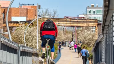
Jonathan Maus reports on a project in planning in Portland, Oregon that would transform the area around the Hollywood Transit Center into a mixed-use, transit-oriented development in a partnership with TriMet and a local nonprofit affordable housing developer.
"Dubbed 'HollywoodHub' the project’s first phase would build 110-120 housing units and ground floor retail on what is now a bus loop and platform adjacent to I-84 and the MAX light rail station on Northeast Hasley Street and 42nd Avenue," according to Maus.
HollywoodHub project planners describe the multi-modal benefits of the project, which aims to connect bus, bike, MAX, and other transit center users.
"Concept drawings show a stair/ramp combo design similar to Pioneer Square downtown that has eight switchbacks," according to Maus. "There are also plans to work with the Portland Bureau of Transportation to make changes on Halsey and 42nd. The website specifically calls out 'safety improvements' and 'pedestrian and bike access improvements.'" According to both Maus and a local expert with knowledge of both the project, and the existing condition of the station, the project is expected to significantly improve pedestrian and bike connections to the station, in addition to the housing and retail uses created by the project.
FULL STORY: HollywoodHUB project would remake bikeway and transit center at 42nd Avenue


Houston Developers Question Mayor’s Stance on Pedestrian Projects
The new mayor’s reversal of road safety projects, some already underway or completed, is raising eyebrows among developers who say residents want walkable, mixed-use streets.
A Framework for Effective Transit-Oriented Development
Six principles for building vibrant, accessible communities with a focus on sustainable transportation.
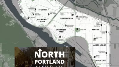
North Portland in Motion Launches with Goals to Improve Walking, Biking, and Transit
The Portland Bureau of Transportation continues its work of drafting transportation plans targeted to specific geographic corners of the city,

Planetizen Federal Action Tracker
A weekly monitor of how Trump’s orders and actions are impacting planners and planning in America.

Maui's Vacation Rental Debate Turns Ugly
Verbal attacks, misinformation campaigns and fistfights plague a high-stakes debate to convert thousands of vacation rentals into long-term housing.

San Francisco Suspends Traffic Calming Amidst Record Deaths
Citing “a challenging fiscal landscape,” the city will cease the program on the heels of 42 traffic deaths, including 24 pedestrians.

Amtrak Rolls Out New Orleans to Alabama “Mardi Gras” Train
The new service will operate morning and evening departures between Mobile and New Orleans.

The Subversive Car-Free Guide to Trump's Great American Road Trip
Car-free ways to access Chicagoland’s best tourist attractions.

San Antonio and Austin are Fusing Into one Massive Megaregion
The region spanning the two central Texas cities is growing fast, posing challenges for local infrastructure and water supplies.
Urban Design for Planners 1: Software Tools
This six-course series explores essential urban design concepts using open source software and equips planners with the tools they need to participate fully in the urban design process.
Planning for Universal Design
Learn the tools for implementing Universal Design in planning regulations.
Heyer Gruel & Associates PA
JM Goldson LLC
Custer County Colorado
City of Camden Redevelopment Agency
City of Astoria
Transportation Research & Education Center (TREC) at Portland State University
Jefferson Parish Government
Camden Redevelopment Agency
City of Claremont