


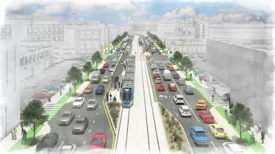
A $7 billion transit investment plan for Austin would include $300 million toward preventing displacement of communities in neighborhoods located near planned transit investments.
"The Austin City Council voted [in July] afternoon to move forward with plans to seek a property tax increase to help fund Project Connect, a plan to build more train and bus lines," reports Samuel King for KUT, Austin's NPR station.
Voters would still have to approve the property tax if the proposal makes it all the way through the City Council process. "The tax increase of 8.75 cents per $100 of property valuation would fund a $7 billion initial expansion of the transit system, as opposed to a higher tax rate of 11 cents that would have funded the full system plan of $10 billion. The council will formally vote next month on whether to put the plan to voters in a November referendum," explains King.
Another big contingency for the plan is funding from the federal government to match the local investment. If the new property tax is approved by voters, the federal government would still be expected to cover 45 percent of the $7 billion plan.
The new revenue generated by the property tax would also include funding for programs intended to mitigate displacement as a result of new development spurred by the city's transit investments. "The plan now calls for a $300 million fund to address displacement, up from $100 million," reports King.
FULL STORY: Austin City Council Wants To Help Prevent People From Getting Priced Out If New Transit Is Built


Austin Hopes to Buck Tradition with Anti-Gentrification Measures in its New Transit Plan
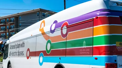
Project Connect promises to prioritize equity and inclusion with $300 million dedicated to anti-displacement efforts.
Austin’s Project Connect Transit Plan Drastically Reduced
The details of drastic reductions to the proposed building program for Austin’s Project Connect long-range transit plan are now open for public comment.
Revisions Looming, Austin’s Project Connect Reveals the Obstacles of Transit Planning in 2023
A once sprawling and singularly ambitious capital investment plan for the Capital Metro system will soon be reduced in size and scope. The episode is more evidence of an emerging era of transit planning austerity.

Maui's Vacation Rental Debate Turns Ugly
Verbal attacks, misinformation campaigns and fistfights plague a high-stakes debate to convert thousands of vacation rentals into long-term housing.

Planetizen Federal Action Tracker
A weekly monitor of how Trump’s orders and actions are impacting planners and planning in America.

San Francisco Suspends Traffic Calming Amidst Record Deaths
Citing “a challenging fiscal landscape,” the city will cease the program on the heels of 42 traffic deaths, including 24 pedestrians.

Defunct Pittsburgh Power Plant to Become Residential Tower
A decommissioned steam heat plant will be redeveloped into almost 100 affordable housing units.

Trump Prompts Restructuring of Transportation Research Board in “Unprecedented Overreach”
The TRB has eliminated more than half of its committees including those focused on climate, equity, and cities.

Amtrak Rolls Out New Orleans to Alabama “Mardi Gras” Train
The new service will operate morning and evening departures between Mobile and New Orleans.
Urban Design for Planners 1: Software Tools
This six-course series explores essential urban design concepts using open source software and equips planners with the tools they need to participate fully in the urban design process.
Planning for Universal Design
Learn the tools for implementing Universal Design in planning regulations.
Heyer Gruel & Associates PA
JM Goldson LLC
Custer County Colorado
City of Camden Redevelopment Agency
City of Astoria
Transportation Research & Education Center (TREC) at Portland State University
Jefferson Parish Government
Camden Redevelopment Agency
City of Claremont