


Urban planning decisions about highway placement in Detroit damaged Black communities. Nithin Vejendla shares an opinion about how to address this legacy and move toward justice.
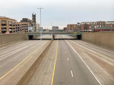
In a recent Detroit Free Press opinion piece, Nithin Vejendla discusses the wave of awareness of racial disparity and systemic racism brought about by the murder of George Floyd. For example, in confronting long-lasting symbols of historical racism and colonial settlerism, the city of Detroit removed a statue of Christopher Columbus from public display. Vejendla says the city should take that action further: "if we’re going to get serious about removing symbols of this country’s endemic racism, we shouldn’t stop there. Detroit’s most persistent, visible, and disruptive symbols of racism are its freeways."
The deliberate destruction of Black communities through the construction of freeways that bisected and uprooted entire neighborhoods in cities like Detroit is a dark legacy recently being confronted by the planning community. In Detroit, the I-375 Chrysler Freeway, the M-10 Lodge Expressway, and the I-94 Edsel Ford Freeway bisected Black neighborhoods and business centers, destroying "some of the African-American community’s most important institutions," explains Vejendla. "To address this terrible legacy, I propose we tear out all the freeways in the greater downtown are of the city," Vejendla opines. Vejendla suggests an alternative path forward including investment in public transit and the payment of reparations to Black Americans with the land reclaimed from the removal of highways.
FULL STORY: Freeways are Detroit's most enduring monuments to racism. Let's excise them.

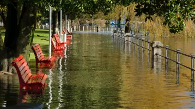
Detroit Floods as the Pacific Northwest Bakes: It's Time to Shift the Conversation About Climate Change
The record-breaking heatwave in the Pacific Northwest has mostly been depicted in the media by kids running through fountains, but images of flooded highways and stranded vehicles in Detroit tell a more accurate story of climate change.
Michigan Gov. Whitmer Proposes 45-Cent Gas Tax Hike in First Budget
Gretchen Whitmer has outdone the new Democratic governor of Minnesota, Tim Walz, who proposed a 20 cents tax hike. Like Walz's budget, gas tax revenue would replace some general funds directed to road spending, thus benefiting other state programs.
Downtown Expressway's Days Are Numbered in Detroit
Detroit will soon join the ranks of cities that have ripped out high-speed freeways from their urban core.

Planetizen Federal Action Tracker
A weekly monitor of how Trump’s orders and actions are impacting planners and planning in America.

Chicago’s Ghost Rails
Just beneath the surface of the modern city lie the remnants of its expansive early 20th-century streetcar system.

San Antonio and Austin are Fusing Into one Massive Megaregion
The region spanning the two central Texas cities is growing fast, posing challenges for local infrastructure and water supplies.

Since Zion's Shuttles Went Electric “The Smog is Gone”
Visitors to Zion National Park can enjoy the canyon via the nation’s first fully electric park shuttle system.

Trump Distributing DOT Safety Funds at 1/10 Rate of Biden
Funds for Safe Streets and other transportation safety and equity programs are being held up by administrative reviews and conflicts with the Trump administration’s priorities.

German Cities Subsidize Taxis for Women Amid Wave of Violence
Free or low-cost taxi rides can help women navigate cities more safely, but critics say the programs don't address the root causes of violence against women.
Urban Design for Planners 1: Software Tools
This six-course series explores essential urban design concepts using open source software and equips planners with the tools they need to participate fully in the urban design process.
Planning for Universal Design
Learn the tools for implementing Universal Design in planning regulations.
planning NEXT
Appalachian Highlands Housing Partners
Mpact (founded as Rail~Volution)
City of Camden Redevelopment Agency
City of Astoria
City of Portland
City of Laramie