


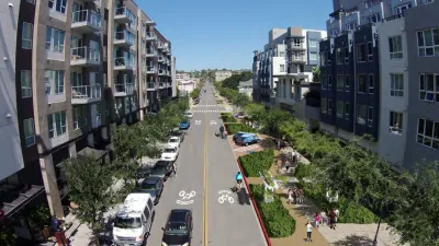
The second most populous city in California, San Diego, wants to revolutionize its approach to planning parks and open space.

"The city of San Diego is on the precipice of replacing a decades-old way of thinking about its parks, emphasizing quality over quantity in a new planning approach that could have profound effects on disadvantaged neighborhoods and older ones already built to capacity," reports Jennifer Van Grove.
The evolution of parks planning in San Diego is encapsulated in a draft version of the city's new Parks Master Plan, released in April. The previous park plan for the city dates back to 1956.
Among the foundational changes proposed by the draft Parks Master Plan is a points system for quantifying the access of residents to quality parks. Today, the city’s parks standard is 2.8 acres for every 1,000 people. "Going forward, the standard will be 12 points for every 1,000 residents, with points representing the recreational value of the park’s size, features, connection to transit or programming," according to Van Grove.
The city will seek input on the draft from the public until the end of May.
FULL STORY: San Diego shakes up citywide approach to parks with focus on access, amenities

San Diego Swaps Parking Lane for Kid-Friendly Mini Park
The block-long greenway will feature interactive play equipment and landscaping.

Serpentine Maze: Pop-Up Parks in the Pandemic
If the combined effects of winter's cold and the pandemic has you bummed, check out this community-building exercise in the frozen North.

Reimagined Public Spaces and Programming During the Pandemic
Public spaces have become more important than ever. Here are five case studies of innovative and safely designed programming that engages people of all ages and backgrounds.

Maui's Vacation Rental Debate Turns Ugly
Verbal attacks, misinformation campaigns and fistfights plague a high-stakes debate to convert thousands of vacation rentals into long-term housing.

Planetizen Federal Action Tracker
A weekly monitor of how Trump’s orders and actions are impacting planners and planning in America.

In Urban Planning, AI Prompting Could be the New Design Thinking
Creativity has long been key to great urban design. What if we see AI as our new creative partner?

Pedestrian Deaths Drop, Remain Twice as High as in 2009
Fatalities declined by 4 percent in 2024, but the U.S. is still nowhere close to ‘Vision Zero.’

King County Supportive Housing Program Offers Hope for Unhoused Residents
The county is taking a ‘Housing First’ approach that prioritizes getting people into housing, then offering wraparound supportive services.

Researchers Use AI to Get Clearer Picture of US Housing
Analysts are using artificial intelligence to supercharge their research by allowing them to comb through data faster. Though these AI tools can be error prone, they save time and housing researchers are optimistic about the future.
Urban Design for Planners 1: Software Tools
This six-course series explores essential urban design concepts using open source software and equips planners with the tools they need to participate fully in the urban design process.
Planning for Universal Design
Learn the tools for implementing Universal Design in planning regulations.
planning NEXT
Appalachian Highlands Housing Partners
Mpact (founded as Rail~Volution)
City of Camden Redevelopment Agency
City of Astoria
City of Portland
City of Laramie