


Climate change and channelization have made high water levels the norm along the river. But low-lying New Orleans lies in its path, and the consequences could be monumental.
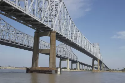
Henry Grabar writes about the rising of the Mississippi River and the threats it poses in southern Louisiana, and particularly to New Orleans. "America’s wettest 12-month period in recorded history, all those devastating floods in Nebraska, Iowa, Oklahoma, Arkansas … it is all coming down through New Orleans now, putting the world’s most ambitious infrastructure of river control to the test."
The river is setting high water records—it is eight feet higher now than it was at this time last year—and the result has been large amounts of very fast-moving water, making navigation of vessels dangerous and travel upstream slow and difficult.
The combination of weather and channelization to keep the river under control has experts worried, says Grabar. The constant stress on the aging levee system could weaken it. And the approach of hurricane season when the river is so high is a concern.
"A storm would have to hit the river mouth just so to cause a major river surge. But as the years go by, it is looking more likely that high water and a hurricane could coincide—and in turn, it becomes more important to rethink the logic of the system that sends so much water through New Orleans into the hot summer months," notes Grabar.
FULL STORY: Hell Is High Water


As Temperatures Increase, Maps Show Sea-Level Rise Will Devastate Cities
Data visualizations illustrate the catastrophic consequences of single-digit global temperature increases.
To Prevent Flooding in New Orleans, Holding Water Rather Than Pumping It
The city plans to use a different approach to tackle its longstanding flood problems.
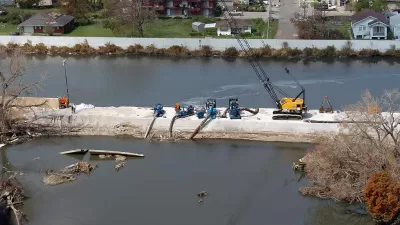
Rethinking New Orleans' Levees
Three design firms offer new ideas for redesigning New Orleans' levees.

Planetizen Federal Action Tracker
A weekly monitor of how Trump’s orders and actions are impacting planners and planning in America.

Maui's Vacation Rental Debate Turns Ugly
Verbal attacks, misinformation campaigns and fistfights plague a high-stakes debate to convert thousands of vacation rentals into long-term housing.

Restaurant Patios Were a Pandemic Win — Why Were They so Hard to Keep?
Social distancing requirements and changes in travel patterns prompted cities to pilot new uses for street and sidewalk space. Then it got complicated.

In California Battle of Housing vs. Environment, Housing Just Won
A new state law significantly limits the power of CEQA, an environmental review law that served as a powerful tool for blocking new development.

Boulder Eliminates Parking Minimums Citywide
Officials estimate the cost of building a single underground parking space at up to $100,000.

Orange County, Florida Adopts Largest US “Sprawl Repair” Code
The ‘Orange Code’ seeks to rectify decades of sprawl-inducing, car-oriented development.
Urban Design for Planners 1: Software Tools
This six-course series explores essential urban design concepts using open source software and equips planners with the tools they need to participate fully in the urban design process.
Planning for Universal Design
Learn the tools for implementing Universal Design in planning regulations.
Heyer Gruel & Associates PA
JM Goldson LLC
Custer County Colorado
City of Camden Redevelopment Agency
City of Astoria
Transportation Research & Education Center (TREC) at Portland State University
Jefferson Parish Government
Camden Redevelopment Agency
City of Claremont