


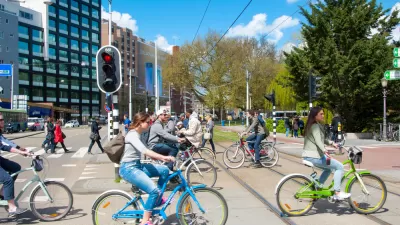
The second biennale in Amsterdam highlights design and infrastructure projects that put biking front and center.
The Bicycle Architecture Biennale recently kicked off in Amsterdam and includes 15 projects from nine countries. The goal of the biennale is to highlight visionary ways that biking can be part of urban and natural landscapes and help create sustainable, cleaner, and healthier cities.
The projects include bike parking structures, bike paths and routes, and other infrastructure that helps to integrate biking into mobility networks. "In Xiamen, [China], an aerial bike path travels for nearly five miles—the longest elevated bike path in the world—with 11 exits to public transit hubs and bike rental for people who are rushing to a nearby bus or subway station. At rush hour, more than 2,000 bikes an hour can fit on the path," writes Adele Peters.
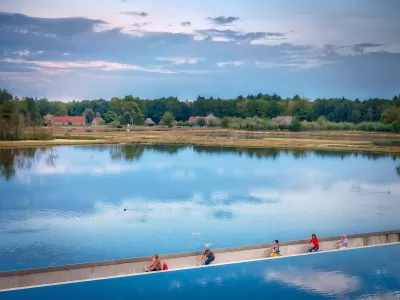
Two projects in Belgium give people access to nature through cycling. "In the middle of a Belgian nature preserve, a sunken bike trail cuts directly through a pond, so cyclists can ride at eye level with the water and glide by swans. The path, called Cycling through Water, helps inspire people to ride bikes; an average of 800 visitors a day now come through the area."
Peters takes a look at all the Bicycle Architecture Biennale projects—some completed and some proposed. The range of innovative ideas is impressive and sure to inspire more creative thinking about the future of biking.
FULL STORY: These 15 mind-blowing bike projects will make you hate your regular bike lane

New Philly Bike Racks Blend Form, Function, Fire Hydrant Access
The clever designs serve multiple purposes—providing more bike parking while getting cars out of illegal parking spaces.
Learning from Europe
European cities tend to be more walkable and transit-accessible—perhaps because they get the three Ds right (density, diversity, and design).
Advocates Finalizing a Wisconsin-Spanning Bike Route
U.S. Bike Route 30, as the planned route that will cross Wisconsin is called, is part of a vision for a national system of bike routes.

Planetizen Federal Action Tracker
A weekly monitor of how Trump’s orders and actions are impacting planners and planning in America.

Restaurant Patios Were a Pandemic Win — Why Were They so Hard to Keep?
Social distancing requirements and changes in travel patterns prompted cities to pilot new uses for street and sidewalk space. Then it got complicated.

Map: Where Senate Republicans Want to Sell Your Public Lands
For public land advocates, the Senate Republicans’ proposal to sell millions of acres of public land in the West is “the biggest fight of their careers.”

Orange County, Florida Adopts Largest US “Sprawl Repair” Code
The ‘Orange Code’ seeks to rectify decades of sprawl-inducing, car-oriented development.

Maui's Vacation Rental Debate Turns Ugly
Verbal attacks, misinformation campaigns and fistfights plague a high-stakes debate to convert thousands of vacation rentals into long-term housing.

San Francisco Suspends Traffic Calming Amidst Record Deaths
Citing “a challenging fiscal landscape,” the city will cease the program on the heels of 42 traffic deaths, including 24 pedestrians.
Urban Design for Planners 1: Software Tools
This six-course series explores essential urban design concepts using open source software and equips planners with the tools they need to participate fully in the urban design process.
Planning for Universal Design
Learn the tools for implementing Universal Design in planning regulations.
Heyer Gruel & Associates PA
JM Goldson LLC
Custer County Colorado
City of Camden Redevelopment Agency
City of Astoria
Transportation Research & Education Center (TREC) at Portland State University
Camden Redevelopment Agency
City of Claremont
Municipality of Princeton (NJ)