


The Minneapolis City Council will consider initial mixed-use development plans for critical riverfront industrial site surrounded by a struggling residential neighborhood.
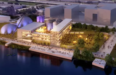
"On Friday, the Minneapolis City Council will vote on a massive plan to turn 48 acres of riverfront land into housing, businesses and an outdoor performance venue," reports Jessica Lee. "The project — the Upper Harbor Terminal — is city officials’ No. 1 construction priority right now."
With the City Council's vote forthcoming, Lee digs into details of the project, which is considered "critical" to the city's economic development plans. The site housed a barge shipping terminal until fears of invasive carp forced the facility to close in 2014.
The project site is surrounded by a federal Promise Zone and a city Green Zone. The surrounding residential areas are defined by median household incomes below the city and regional average.
The City Council will consider the project's "General Land-Use Concept" on Friday, which lays the groundwork for more detailed design and planning work to follow.
Lee provides additional details about the funding challenges facing the project, as well as the tough political path the plan had to arrive at this point in its evolution.
FULL STORY: Everything you need to know, for now, about Minneapolis’ Upper Harbor Terminal project


Minneapolis Riverfront Project Raises Issues of Equity
The Upper Harbor Terminal project is set to transform an area north of downtown, but residents are concerned about the long-term impacts and outcomes.
Stories of Big Box Redevelopment Success—After Years of Frustration
The Minneapolis area yields two case studies of troubled sites, home to big box retailers, finally rejoining the community.

Looking Back on 60 Years of Land Development in the Twin Cities
In 1960, about 12 percent of the Twin Cities metro's land was already developed. By 2020, about 34 percent had been developed. Many factors influenced how the region has changed since 1960.

Planetizen Federal Action Tracker
A weekly monitor of how Trump’s orders and actions are impacting planners and planning in America.

Maui's Vacation Rental Debate Turns Ugly
Verbal attacks, misinformation campaigns and fistfights plague a high-stakes debate to convert thousands of vacation rentals into long-term housing.

San Francisco Suspends Traffic Calming Amidst Record Deaths
Citing “a challenging fiscal landscape,” the city will cease the program on the heels of 42 traffic deaths, including 24 pedestrians.

Amtrak Rolls Out New Orleans to Alabama “Mardi Gras” Train
The new service will operate morning and evening departures between Mobile and New Orleans.

The Subversive Car-Free Guide to Trump's Great American Road Trip
Car-free ways to access Chicagoland’s best tourist attractions.

San Antonio and Austin are Fusing Into one Massive Megaregion
The region spanning the two central Texas cities is growing fast, posing challenges for local infrastructure and water supplies.
Urban Design for Planners 1: Software Tools
This six-course series explores essential urban design concepts using open source software and equips planners with the tools they need to participate fully in the urban design process.
Planning for Universal Design
Learn the tools for implementing Universal Design in planning regulations.
Heyer Gruel & Associates PA
JM Goldson LLC
Custer County Colorado
City of Camden Redevelopment Agency
City of Astoria
Transportation Research & Education Center (TREC) at Portland State University
Jefferson Parish Government
Camden Redevelopment Agency
City of Claremont