


Six-month pilot projects along the Sunset Strip include a parklet and painted sidewalk extensions by a street artist.
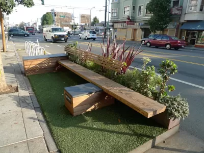
The city of West Hollywood, which encompasses L.A.'s famed Sunset Strip, is getting in on pop-up parklets and experimental walkability interventions. Partnering with design and planning firm Gehl Studio, the city has installed temporary pilot projects "that aim to improve walkability and create a more pedestrian-friendly environment for residents and visitors," Wehoville reports.
The projects, dubbed "The Sunset Experience," include "light poles wrapped in bright colors with directions to nearby restaurants and clubs along with historic facts about the Strip," as well as "painted extensions of the sidewalks at key intersections, narrowing the distance to cross some streets while adding a colorful and driver-aware flair to the roadway." There's also a shaded and screened parklet located at an on-street loading zone.
The project brought on The Art of Chase, a street artist, to design the sidewalk extensions. According to the city of West Hollywood's website, the pilot project may pave the way for additional "corridor-length streetscape improvements, intersection treatments, site-specific interventions and programming suggestions to activate streetlife and improve pedestrian safety, as well as a process for using additional pop-ups to test, measure and refine changes to the design and programming of Sunset Boulevard."
FULL STORY: ‘The Sunset Experience’ Hopes to Improve Walkability on the Sunset Strip

Luxury Developments Moving into the Sunset Strip; Porn and Clubs, Moving Out.
The 1.6 mile stretch of Sunset Boulevard in the city West Hollywood is destined for more than $600 million in developments planned or already being built, mostly composed of luxury hotels and condominiums.
L.A. Might be Forced to Fix Its Crumbling Sidewalks
A lawsuit based on the Americans With Disabilities Act may leave Los Angeles responsible for over a billion dollars' worth of crumbling sidewalks.
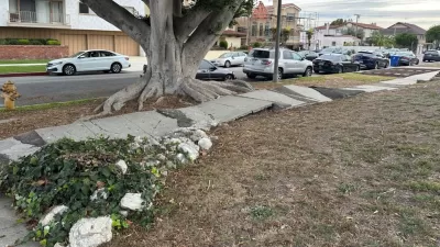
The City of Broken Sidewalks
Can Los Angeles fix 4,000 miles of broken sidewalks before the city hosts the 2028 Olympic Games?

Planetizen Federal Action Tracker
A weekly monitor of how Trump’s orders and actions are impacting planners and planning in America.

Chicago’s Ghost Rails
Just beneath the surface of the modern city lie the remnants of its expansive early 20th-century streetcar system.

San Antonio and Austin are Fusing Into one Massive Megaregion
The region spanning the two central Texas cities is growing fast, posing challenges for local infrastructure and water supplies.

Since Zion's Shuttles Went Electric “The Smog is Gone”
Visitors to Zion National Park can enjoy the canyon via the nation’s first fully electric park shuttle system.

Trump Distributing DOT Safety Funds at 1/10 Rate of Biden
Funds for Safe Streets and other transportation safety and equity programs are being held up by administrative reviews and conflicts with the Trump administration’s priorities.

German Cities Subsidize Taxis for Women Amid Wave of Violence
Free or low-cost taxi rides can help women navigate cities more safely, but critics say the programs don't address the root causes of violence against women.
Urban Design for Planners 1: Software Tools
This six-course series explores essential urban design concepts using open source software and equips planners with the tools they need to participate fully in the urban design process.
Planning for Universal Design
Learn the tools for implementing Universal Design in planning regulations.
planning NEXT
Appalachian Highlands Housing Partners
Mpact (founded as Rail~Volution)
City of Camden Redevelopment Agency
City of Astoria
City of Portland
City of Laramie