


Cities like San Francisco and Los Angeles already keep lists of vulnerable buildings, but a new piece of legislation would require all California cities do the same. The catch? The bill will not provide funding to support these lists.
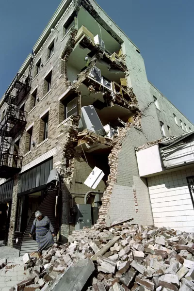
Experts can spot certain tell-tale signs of earthquake vulnerability right away, but for those who aren't experts it can be harder to identify possibly dangerous buildings. "Now the Legislature has sent to Gov. Jerry Brown a bill that would require cities and counties in the state’s most seismically vulnerable areas to create lists of buildings that could be at higher risk of major damage or collapse," Rong-Gong LIN II writes for the Los Angeles Times.
Those opposed to the bill point out that it creates no provision for funding the creation of this list. "But backers of the bill say creating a list of possibly vulnerable buildings would represent a major step in alerting Californians whether the buildings in which they live and work should receive more study to determine whether they’re at risk in an earthquake," Lin writes. Representatives from cities like San Francisco and Los Angeles, who already maintain this type of list, say it's irresponsible for cities likely to be affected by seismic activity not to alert their citizens of the risks they face. How much would that cost? "Rough estimates published by legislative staffers say that while amounts are uncertain, costs that might need reimbursement by the state could be in the tens of millions of dollars to create an inventory by 2021, with a total possibly exceeding $100 million," Lin reports.
FULL STORY: Fearing massive earthquake, California considers requiring lists of buildings most likely to collapse


Bay Area Not Prepared for Next Big One
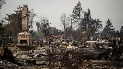
As the death toll from Mexico's 7.1 magnitude earthquake on Sept. 19 climbs above 300, the San Francisco Chronicle investigates how well prepared the Bay Area is for an earthquake of comparable magnitude. Not very well.
Lessons on Resilience and Recovery from 2017's Worst Disasters
Dissecting successful disaster response in places like Houston and Mexico City could help California prepare for the inevitable.
Los Angeles Releases Large-Scale Earthquake Preparedness Plan
Los Angeles has been hard at work, under the leadership of Dr. Lucy Jones, to prepare for the ever-present threat of earthquakes. The Office of Mayor Eric Garcetti released the plan, called "Resilience by Design," earlier this week.

Planetizen Federal Action Tracker
A weekly monitor of how Trump’s orders and actions are impacting planners and planning in America.

Restaurant Patios Were a Pandemic Win — Why Were They so Hard to Keep?
Social distancing requirements and changes in travel patterns prompted cities to pilot new uses for street and sidewalk space. Then it got complicated.

Map: Where Senate Republicans Want to Sell Your Public Lands
For public land advocates, the Senate Republicans’ proposal to sell millions of acres of public land in the West is “the biggest fight of their careers.”

Orange County, Florida Adopts Largest US “Sprawl Repair” Code
The ‘Orange Code’ seeks to rectify decades of sprawl-inducing, car-oriented development.

Maui's Vacation Rental Debate Turns Ugly
Verbal attacks, misinformation campaigns and fistfights plague a high-stakes debate to convert thousands of vacation rentals into long-term housing.

San Francisco Suspends Traffic Calming Amidst Record Deaths
Citing “a challenging fiscal landscape,” the city will cease the program on the heels of 42 traffic deaths, including 24 pedestrians.
Urban Design for Planners 1: Software Tools
This six-course series explores essential urban design concepts using open source software and equips planners with the tools they need to participate fully in the urban design process.
Planning for Universal Design
Learn the tools for implementing Universal Design in planning regulations.
Heyer Gruel & Associates PA
JM Goldson LLC
Custer County Colorado
City of Camden Redevelopment Agency
City of Astoria
Transportation Research & Education Center (TREC) at Portland State University
Camden Redevelopment Agency
City of Claremont
Municipality of Princeton (NJ)