


After tremendous success with a streetcar line, the desert city is considering strategies for investing in its historic automobile corridor.
Four years ago, the Sunlink streetcar began running a route originating at the University of Tucson, along 4th Avenue, through downtown, and to the Mercado District. With its success came the kind of business and residential activity seen in other cities that have invested in transit, to the point where, four years later, formerly desolate areas are concerned.
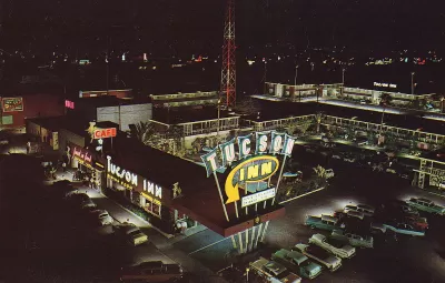
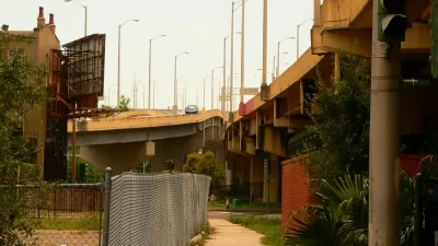
Other areas of Tucson have not fared as well, namely what was once referred to as the Miracle Mile, a stretch of road on the north side of the city that once served as an "automobile gateway.
"With its Old Spanish Trail marketing, Tucson was one of the first cities to promote automobile-based tourism," Gideon Berger writes at CitiesSpeak. "As vehicle ownership skyrocketed in the 1920s, business catering to 'auto-camping' tourists flourished along corridors leading to the city. Eventually, these grew to include 'motor courts' with cabin lodging and some of the nation’s first motels."
Like similar areas in other American cities, the construction of an interstate highway—in this case I-10—Miracle Mile sent the neighborhood into decline.
After its recent success in redevelopment, Tucson won a land use fellowship from the Rose Center for Public Leadership and has revisited the Miracle Mile.
Berger, who is the director of the program for the Rose Center, enumerates a lengthy list of areas for which the fellowship developed recommendations, including both economic and cultural development and protecting residents from the kind of displacement that this sort of development can mean for those who live in it.
FULL STORY: Can Tucson, Arizona Bring Back its Miracle Mile?


The Foundational Myth of America's Interstate Highway System
The erroneous belief that the negative impacts of interstate highways are simply "unintended consequences" fails to demand accountability for the project's failures.
How Federal Funds Can Benefit Freeway Removal Projects
The recently passed infrastructure bill dedicates $1 billion to freeway removal and capping, but the sum is only a 'first step' toward redressing the injustices perpetuated by urban highway projects.

Richmond 300 Plan Update Includes New Cap Park, Form-Based Code
Richmond, Virginia is hoping to make some big changes in time for its tricentennial in 2037, including a new cap park and a new form-based code.

Maui's Vacation Rental Debate Turns Ugly
Verbal attacks, misinformation campaigns and fistfights plague a high-stakes debate to convert thousands of vacation rentals into long-term housing.

Planetizen Federal Action Tracker
A weekly monitor of how Trump’s orders and actions are impacting planners and planning in America.

In Urban Planning, AI Prompting Could be the New Design Thinking
Creativity has long been key to great urban design. What if we see AI as our new creative partner?

King County Supportive Housing Program Offers Hope for Unhoused Residents
The county is taking a ‘Housing First’ approach that prioritizes getting people into housing, then offering wraparound supportive services.

Researchers Use AI to Get Clearer Picture of US Housing
Analysts are using artificial intelligence to supercharge their research by allowing them to comb through data faster. Though these AI tools can be error prone, they save time and housing researchers are optimistic about the future.

Making Shared Micromobility More Inclusive
Cities and shared mobility system operators can do more to include people with disabilities in planning and operations, per a new report.
Urban Design for Planners 1: Software Tools
This six-course series explores essential urban design concepts using open source software and equips planners with the tools they need to participate fully in the urban design process.
Planning for Universal Design
Learn the tools for implementing Universal Design in planning regulations.
planning NEXT
Appalachian Highlands Housing Partners
Mpact (founded as Rail~Volution)
City of Camden Redevelopment Agency
City of Astoria
City of Portland
City of Laramie