


The Neuse River is returning to its natural state.

"Less than two weeks after workers began clawing away at it, the Milburnie Dam is gone, and the Neuse River is flowing freely through Raleigh for the first time in centuries," reports Richard Stradling.
The dam was built in 1900 for electric power, "creating what was essentially a narrow six-mile-long lake on the east side of Raleigh."
Raleigh-based company Restoration Systems is spending millions to remove the dam and restore the river to its natural state, but the freedom of the Neuse River comes at a cost. "The company will make that back by selling mitigation credits to governments or developers who are required to compensate for destroying streams and wetlands elsewhere," according to Stradling.
"Its largest customer… will likely be the N.C. Department of Transportation, which will in essence pay to restore six miles of the Neuse River to partially make up for the streams and other habitat it will destroy in building N.C. 540 across southern Wake County in the coming years," according to Stradling.
FULL STORY: Raleigh’s Milburnie Dam is gone, unleashing the Neuse River

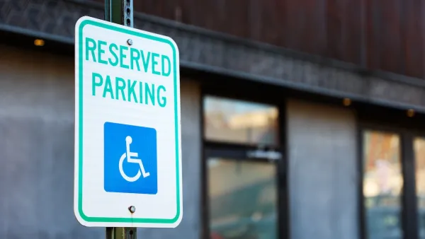
Raleigh Pilots App-Based Feedback Program for Accessible Parking
The city is using the program to collect real-time information about accessibility issues and correct them quickly.

Raleigh Launches Greenway Food Truck Pilot to Enhance Park Experiences
Raleigh’s new Greenway Food Truck Pilot Program brings local food vendors to popular greenway locations to enhance park experiences, support small businesses, and encourage community use of public spaces.
Raleigh Announces Safe Streets Plan
The city wants to eliminate traffic deaths by 2045.

Planetizen Federal Action Tracker
A weekly monitor of how Trump’s orders and actions are impacting planners and planning in America.

Restaurant Patios Were a Pandemic Win — Why Were They so Hard to Keep?
Social distancing requirements and changes in travel patterns prompted cities to pilot new uses for street and sidewalk space. Then it got complicated.

Map: Where Senate Republicans Want to Sell Your Public Lands
For public land advocates, the Senate Republicans’ proposal to sell millions of acres of public land in the West is “the biggest fight of their careers.”

Maui's Vacation Rental Debate Turns Ugly
Verbal attacks, misinformation campaigns and fistfights plague a high-stakes debate to convert thousands of vacation rentals into long-term housing.

San Francisco Suspends Traffic Calming Amidst Record Deaths
Citing “a challenging fiscal landscape,” the city will cease the program on the heels of 42 traffic deaths, including 24 pedestrians.

California Homeless Arrests, Citations Spike After Ruling
An investigation reveals that anti-homeless actions increased up to 500% after Grants Pass v. Johnson — even in cities claiming no policy change.
Urban Design for Planners 1: Software Tools
This six-course series explores essential urban design concepts using open source software and equips planners with the tools they need to participate fully in the urban design process.
Planning for Universal Design
Learn the tools for implementing Universal Design in planning regulations.
Heyer Gruel & Associates PA
JM Goldson LLC
Custer County Colorado
City of Camden Redevelopment Agency
City of Astoria
Transportation Research & Education Center (TREC) at Portland State University
Camden Redevelopment Agency
City of Claremont
Municipality of Princeton (NJ)