


The product of a single developer, San Jose's Santana Row is a pocket of urbanism in a sea of sprawl. But can it influence development patterns beyond its bounds, and should it?
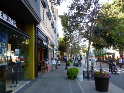
For the Congress for the New Urbanism's Public Square, Robert Steuteville discusses the merits of intentionally "urbanist" developments like San Jose's retail-oriented Santana Row. "Santana Row is better than the usual Silicon Valley sprawl, but does it represent real progress—or is it merely dressing up a mess of disconnected development?"
Steuteville notes that in Silicon Valley, "The tech industry did not create sprawl. It accelerated sprawl by creating hundreds of thousands of high-paying jobs that kicked housing demand into overdrive. But [sprawl] was formed by, among other factors, government-adopted zoning codes and publicly built road systems that funnel traffic from housing and shopping pods onto large, wide thoroughfares."
The article covers how Santana Row interacts with neighboring arterials and whether a centrally-planned development can truly influence the surrounding sprawl.
Steuteville argues that developers alone cannot reshape urban environments. "The reality is that new urbanists have made far less impact on transportation engineering than they would like. [...] Expecting a developer to solve a thoroughfare or context problem that exists at a far larger scale than the development site is unrealistic."
FULL STORY: Genuine change or lipstick on a pig?


Why Is Silicon Valley So Bleak?
The built environment in one of the most affluent places in the country leaves much to be desired. Why are Silicon Valley communities missing so many key urban features?
A Primer on Suburban Urbanism
How one master-planned development used lower-density urbanism principles to build a community focused on affordability, sustainability, and conservation.
A ‘New Urbanism’ Travelogue
I visited three New Urbanist developments in North Carolina. Here's what I liked, what I didn't like, and what I learned.

Maui's Vacation Rental Debate Turns Ugly
Verbal attacks, misinformation campaigns and fistfights plague a high-stakes debate to convert thousands of vacation rentals into long-term housing.

Planetizen Federal Action Tracker
A weekly monitor of how Trump’s orders and actions are impacting planners and planning in America.

San Francisco Suspends Traffic Calming Amidst Record Deaths
Citing “a challenging fiscal landscape,” the city will cease the program on the heels of 42 traffic deaths, including 24 pedestrians.

Detroit Says Problems With Property Tax Assessments are Fixed. Advocates Disagree.
With higher-valued properties under assessed and lower-valued properties over assessed, advocates say there's still a problem with Detroit's property tax system.

Defunct Pittsburgh Power Plant to Become Residential Tower
A decommissioned steam heat plant will be redeveloped into almost 100 affordable housing units.

Trump Prompts Restructuring of Transportation Research Board in “Unprecedented Overreach”
The TRB has eliminated more than half of its committees including those focused on climate, equity, and cities.
Urban Design for Planners 1: Software Tools
This six-course series explores essential urban design concepts using open source software and equips planners with the tools they need to participate fully in the urban design process.
Planning for Universal Design
Learn the tools for implementing Universal Design in planning regulations.
Heyer Gruel & Associates PA
JM Goldson LLC
Custer County Colorado
City of Camden Redevelopment Agency
City of Astoria
Transportation Research & Education Center (TREC) at Portland State University
Jefferson Parish Government
Camden Redevelopment Agency
City of Claremont