


Racist and colonialist narratives in old geography textbooks help explain the prevalence of segregationist and discriminatory policies and other nasty planning practices. It’s time to understand and reconcile.

Greetings from Denver, Colorado, where I am attending the American Association of Geographers Annual Meeting. Tomorrow, I present a paper titled, “Racism and Colonialism in Geography Textbooks, 1840s to 1950s” (slideshow and full report) which describes how old school textbooks portrayed foreign peoples and cultures, and discusses how they influenced popular beliefs about race, culture, and colonialism.
Old geography textbooks contained racist and colonialist narratives that justified discriminatory and harmful planning practices. Information about this history can help us better understand and correct this ugly legacy.
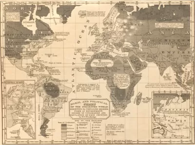
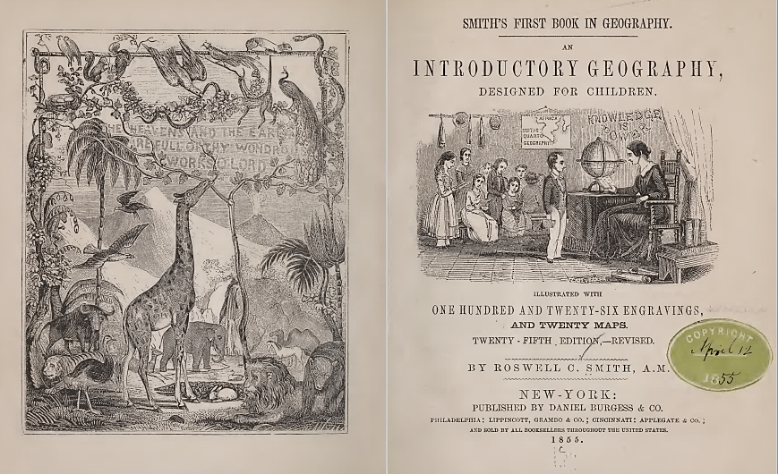
This research is based on my personal collection of old geography books—I own a few dozen, some more than two centuries old. I find these documents beautiful and fascinating; they are little time machines that show how previous generations perceived the larger world. Geography textbooks introduced children to foreign lands and people. Considered scientific and authoritative, they left a durable legacy on students' worldviews. If previous generations thought about China, Africa, or South America, they probably based their understanding of those places and their peoples on the brief descriptions in their grade school geography books.
My study includes texts and images scanned from these books. You probably would not be surprised to learn that old geography books were overtly racist (they claimed that White races are superior) and colonialist (they claimed that European imperialism was benevolent and beneficial), but it is still shocking to see how systematically they used pseudoscience to categorize non-white races and cultures as violent, immoral, lazy, ignorant, and generally inferior, establishing a foundation for exclusionary and oppressive policies.
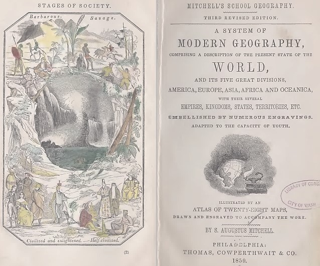
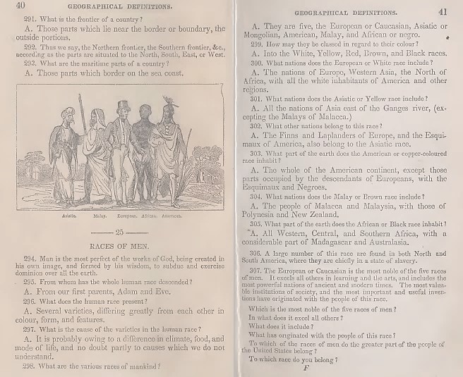
Early geography textbooks categorized race and culture using methods modeled after biological taxonomies, giving them a veneer of scientific objectivity. They identified various races (European [White], Asiatic [Yellow], African [Black], Malayan [Brown], and American Indian [Red]), which were categorized according to “stages of society” (savage, barbarous, half-civilized, civilized, and enlightened).
Unsurprisingly, European and North American textbooks ranked Europeans highest and described other races and cultures as intellectually and morally inferior. They also argued that natives benefitted from colonialization and “progressed” to the degree that they adopted Western values and practices. This allowed Whites to feel superior to other peoples and supported colonialist policies.
Here is a typical quote:
“The European or Caucasian is the most noble of the five races of men. It excels all others in learning and the arts, and includes the most powerful nations of ancient and modern times. The most valuable institutions of society, and the most important and useful inventions, have originated with the people of this race.”
These racist messages in authoritative textbooks contributed to a self-reinforcing cycle of racist beliefs, discriminatory policies, segregation and isolation, inferior education and employment opportunities, lower self-esteem, and poor economic outcomes for minority groups, which justified more racist beliefs.
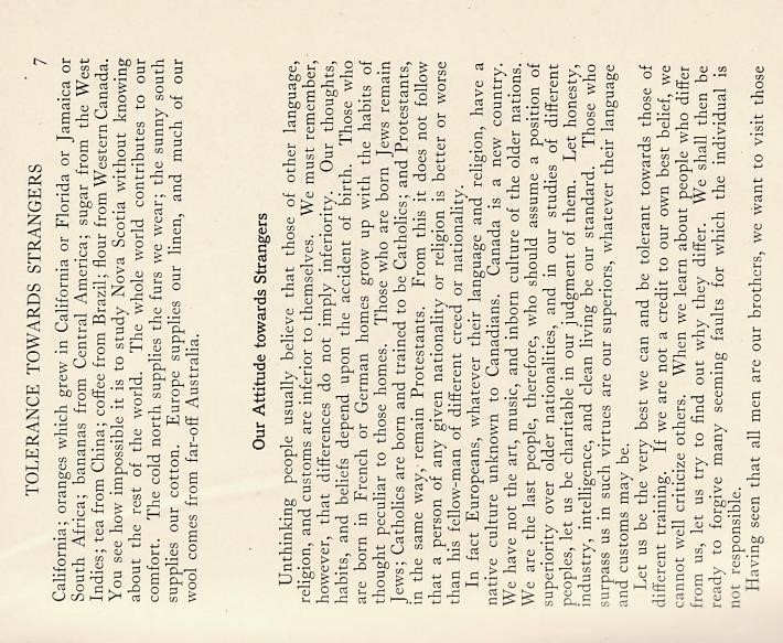
These descriptions changed over time. Textbooks published from 1900 to 1940 had less overt racial hierarchies but still emphasized the superiority of western institutions and the benefits that colonization provided to natives. Textbooks published after 1940 often provided positive stories about foreign people, cultures, and immigrants, and some encouraged students to critically analyze racism and colonialism. Here is a quote from a 1934 textbook:
“Unthinking people usually believe that that those of other language, religion, and culture are inferior to themselves. We must remember, however, that differences do not imply inferiority. Our thoughts, habits, and beliefs depend upon the accident of birth…From this it does not follow that a person of any given nationality or religion is better or worse than his follow-man of different creed or nationality.”
Many racist textbooks published in the 1940s were probably still in use in the 1960s and affected the beliefs of current generations. Current racial and ethnic discrimination is, to some degree, a legacy of geography textbook lessons that portrayed non-whites as culturally, intellectually, and morally inferior, and therefore dangerous and unproductive.
One specific example is the common practice of building freeways that destroyed minority urban neighborhoods, as described in “Interstate Injustice: Plowing Highways Through Minority Neighborhoods” and Deborah Archer's study “White Men’s Roads Through Black Men’s Homes’: Advancing Racial Equity Through Highway Reconstruction.”
It is striking how little respect planners gave to minority neighborhoods. In fact, they often described low-income and minority community as blight to be displaced when possible. For example, a 1978 Transportation Research Board report, Beneficial Effects Associated with Freeway Construction, stated that “Old housing of low quality occupied by poor people often serves as a reason for the destruction of that housing for freeway rights of way.” It claimed that freeways improve safety, environmental quality, economic productivity and aesthetics:
“Blighted or substandard housing, junkyards, dumps, and other sources of ugliness may be eliminated through condemnation, eminent domain, out-right purchase, and other procedures. The effect is a reduction in visual discontinuity to the highway viewer and a possible improvement in the entire visual quality of the affected area and the community.”
Most planners I know are ashamed of such insensitivity. These attitudes and practices caused the destruction of very accessible, multimodal neighborhoods, displacing low-income, minority communities for the benefit of suburban motorists and contributing to a cycle of automobile dependency and sprawl. We now recognize these policies as racist, classist, and harmful, as discussed in the Federal Reserve Bank study, “Freeway Revolts!” We now have an obligation to correct these injustices.
Many professional organizations now have programs to support multiculturalism. For example, the American Anthropological Association’s website, Race: Are We So Different?, critically examines the treatment of race at various times and locations, and provides resources for improving our understanding of race and overcoming prejudices. The American Association of Geographers has a new Justice, Equality, Diversity and Inclusions program, the American Planning Association has an Equity, Diversity and Inclusion program, and many of the papers and posters I’ve seen at this annual meeting address equity and inclusion goals.
Planners have an important responsibility to better understand the roots of racist, discriminatory policies, their current impacts on our communities, and ways to correct this ugly legacy. We can do better!
For More Information
Avril M C Maddrell (1998), “Discourses of Race and Gender and the Comparative Method in Geography School Texts 1830-1918,” Environment and Planning D: Society and Space, Vo. 16, pp. 81 103.
Michael Keevak (2011), Introduction No Longer White: The Nineteenth-Century Invention of Yellowness, Princeton University Press.
Todd Litman (2022), “Evaluating Transportation Equity: Guidance for Incorporating Distributional Impacts in Transport Planning,” ITE Journal, Vo. 92/4.
Todd Litman (2023),Racism and Colonialism in Geography Textbooks, 1840s to 1950s (slideshow and full report), Victoria Transport Policy Institute.
Royal Geographical Society's Race, Culture and Equality Working Group (RACE) promotes anti-racist initiatives.
The Decolonising Geography Educators Group works to decolonise geography curriculum.
Humor resources include the Parody Tests for Anti-Racist and Decolonial Geography School Teaching and Kayonga Kagame Shows Us The World. Episode: Darkest Austria.
Race: Are We So Different?, by the American Anthropological Association.


Watch: Segregation's Terrible Legacy in U.S. Cities
"Segregation by Design" is a new film available to the public on Vimeo.

Rethinking Redlining
For decades we have blamed 100-year-old maps for the patterns of spatial racial inequity that persist in American cities today. An esteemed researcher says: we’ve got it all wrong.

Report: How Outdated Zoning Rules Still Shape Boston
Classist and racist zoning decisions from decades past reverberate in today’s neighborhoods.

Planetizen Federal Action Tracker
A weekly monitor of how Trump’s orders and actions are impacting planners and planning in America.

Map: Where Senate Republicans Want to Sell Your Public Lands
For public land advocates, the Senate Republicans’ proposal to sell millions of acres of public land in the West is “the biggest fight of their careers.”

Restaurant Patios Were a Pandemic Win — Why Were They so Hard to Keep?
Social distancing requirements and changes in travel patterns prompted cities to pilot new uses for street and sidewalk space. Then it got complicated.

Platform Pilsner: Vancouver Transit Agency Releases... a Beer?
TransLink will receive a portion of every sale of the four-pack.

Toronto Weighs Cheaper Transit, Parking Hikes for Major Events
Special event rates would take effect during large festivals, sports games and concerts to ‘discourage driving, manage congestion and free up space for transit.”

Berlin to Consider Car-Free Zone Larger Than Manhattan
The area bound by the 22-mile Ringbahn would still allow 12 uses of a private automobile per year per person, and several other exemptions.
Urban Design for Planners 1: Software Tools
This six-course series explores essential urban design concepts using open source software and equips planners with the tools they need to participate fully in the urban design process.
Planning for Universal Design
Learn the tools for implementing Universal Design in planning regulations.
Heyer Gruel & Associates PA
JM Goldson LLC
Custer County Colorado
City of Camden Redevelopment Agency
City of Astoria
Transportation Research & Education Center (TREC) at Portland State University
Camden Redevelopment Agency
City of Claremont
Municipality of Princeton (NJ)