


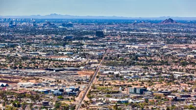
Revisiting one day in 2012, a reporter finds that many of the Dallas-Fort Worth areas affected by the storms were barely inhabited 20 years ago.

At the Texas Tribune, Daniel Levy recounts one day in 2012 during which 17 tornadoes caused $700 million in damages across the Dallas-Fort Worth area. It’s partly memorable for the 110 airplanes taken out, but it’s also memorable because it demonstrates how sprawl makes people and places more vulnerable to natural disasters.
The strongest tornado of the day struck Forney, a suburb 20 miles east of downtown Dallas. Forney has grown by more than 230 percent since 2000, adding 13,000 residents. At 2:33 p.m., an EF-3 tornado with peak winds of 170 mph tore through more neighborhoods, including the Diamond Creek subdivision, that didn’t exist a decade before.
The article includes a map showing the various paths of the various tornadoes; it demonstrates that many of them of them started, ended or passed through areas that have only been developed in the last 20 years, and others passed through areas that will likely be developed in the next 20.
FULL STORY: As cities sprawl, more Texans are exposed to tornadoes


Dallas Code Reform Makes Way for Missing Middle Housing
The Dallas City Council voted to change the city’s building code to allow up to eight residential units in three-story buildings.

Zoning for Good
A new book highlights the power of zoning to change communities for the better.
Is Sprawl the Only Answer to High Housing Costs?
A recent article argues that sprawl is the solution to high housing costs, pointing out that low-density Sunbelt cities are more affordable than some more compact metro areas. What's wrong with this argument?

Planetizen Federal Action Tracker
A weekly monitor of how Trump’s orders and actions are impacting planners and planning in America.

DARTSpace Platform Streamlines Dallas TOD Application Process
The Dallas transit agency hopes a shorter permitting timeline will boost transit-oriented development around rail stations.

Four Reasons Urban Planners Can’t Ignore AI
It’s no longer a question of whether AI will shape planning, but how. That how is up to us.

Amtrak’s Borealis Exceeds First Year Ridership Expectations
205,800 passengers have boarded the St. Paul to Chicago line, well above initial MDOT projections.

Study: 4% of Truckers Lack a Valid Commercial License
Over 56% of inspected trucks had other violations.

Chicago Judge Orders Thousands of Accessible Ped Signals
Only 3% of the city's crossing signals are currently accessible to blind pedestrians.
Urban Design for Planners 1: Software Tools
This six-course series explores essential urban design concepts using open source software and equips planners with the tools they need to participate fully in the urban design process.
Planning for Universal Design
Learn the tools for implementing Universal Design in planning regulations.
City of Mt Shasta
City of Camden Redevelopment Agency
City of Astoria
Transportation Research & Education Center (TREC) at Portland State University
US High Speed Rail Association
City of Camden Redevelopment Agency
Municipality of Princeton (NJ)