The Lyft geofencing pilot in San Francisco will direct drivers to less busy side streets for pick ups and drop offs.


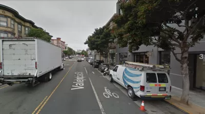
Transportation network company Lyft launched a new program in Sn Francisco last week that sets up a "geofence" to block pick up and drop offs on sections of busy streets.
Michael Toren reports that the first application of the geofencing technology has been implemented on Valencia Street in the Mission. The geofence requires drivers to move a certain number of its pick ups and drop offs on a specific section of busy street to a side street.
The prospect of TNCs limiting their operations along busy corridors is a new twist in an emerging and ongoing discussion about how space is allocated to cars—for instance, as ride hailing and Internet delivery services gain in popularity, some cities are rethinking the allocation of curb space to off-street parking. With this geofencing program, however, we see the other side of the same coin—ride hailing stepping aside to make priority for other modes of transportation.
Hat tip to Katie Pyzyk for sharing the article.
Read the full story: Lyft moving pickups off parts of Valencia Street

How Much of Traffic is Created by Uber and Lyft?
New data from Fehr & Peers shows services like Uber and Lyft account for a larger share of the total traffic than previously thought, especially in city centers.

Ride-Hailing Companies Agree to Tax in San Francisco
Essentially, Uber and Lyft chose a tax on rides instead of a gross-receipts tax.
Can Robotaxis Handle London's Famously Tangled Streets?
Black Cab drivers say autonomous cars won’t be able to handle London’s unique conditions.

Planetizen Federal Action Tracker
A weekly monitor of how Trump’s orders and actions are impacting planners and planning in America.

California plans to bury El Niño’s downpour
If the state plays its cards right, it may be able to store a billion acre-feet of El Niño’s water in aquifers.

Chicago breaks ground on $3 billion megadevelopment
The new neighborhood, titled Foundry Park, will one day host 3,700 residences.

Satanic Place Names
From streams and lakes to valleys and canyons, I mapped more than 1,000 places named after the Devil.

California High-Speed Rail Authority CEO resigns after $600,000 scandal
Under Ian Choudri, the authority used taxpayer dollars to fund first class flights and trips to nightclubs.

Want to study the Missouri River? Soon, you may need unanimous approval from 10 states
Legislation would require 10 governors’ permission to study or build projects moving water outside the basin.

FREE Course: Walkable City 1: Why Walkability?
After describing his path towards focusing on walkability as the essence of good planning, Jeff Speck marches through his five principal reasons for making more walkable places.
Reinventing Malls: Planning Alchemy—Turning Gray Fields Into Gold
The course focuses on the opportunities and imperatives that shape reinvention of mall sites.

City of Rosemead
Rutgers University, Edward J. Bloustein School of Planning and Public Policy
One Hundred Miles
Hunter College, City University of New York (CUNY)
The Architects Foundation
University of Cincinnati Online
City of Cambridge
Montrose County
The Pocatello Development Authority