


The second and third parts in resiliency expert Dave Hampton's 3-part series on what the California fires teach us about preparing for climate change.

In this three part series, resiliency expert Dave Hampton examines the recent California fires for lessons on preparing for the increasing number of disasters anticipated in connection with a warming global climate. In the first part, also summarized in Planetizen, Hampton discussed the difference between "attribution" and "contribution" when discussing the role of climate change in natural disasters.
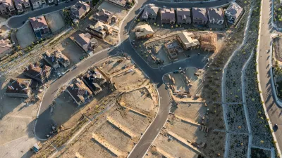
In the second part, Hampton notes that use of the term "wildfires" is distracting. The "wildland-urban interface" (or WUI) must be the focus of preparation and prevention efforts. WUI “refers to the zone of transition between unoccupied land and human development. Communities that are within 0.5 miles (0.80 km) of the zone may also be included.” (Citing Radeloff et al. (2005))
In the third part, Hampton discusses key concepts from the International Wildland-Urban Interface Code (IWUIC). He then goes on to discuss some recent failures due, in part, to outdated models and maps, and the need to be proactive in developing new fire and flood maps and codes. For more details, read the source article.
FULL STORY: Lessons from the California Fires: Climate Change Impacts and Proactive Planning (part 3)

Report Outlines Strategies for Resilient Wildfire Recovery in LA
Project Recovery offers a roadmap for rebuilding more sustainable and climate-resilient communities after wildfires and other disasters.

Building Resilient Communities: Insights from the LA County Cities Summit
The Los Angeles County Cities Summit convened local leaders to share strategies for advancing sustainability, addressing climate resilience, extreme heat, and other pressing environmental challenges through policy and community-driven solutions.

Rebuilding After Disaster: The Role of Social Connections in Resilience
Dr. Lucy Jones emphasizes that resilience in the face of climate-driven disasters like wildfires relies on building strong social connections, which empower communities to recover and adapt to an increasingly challenging future.

Planetizen Federal Action Tracker
A weekly monitor of how Trump’s orders and actions are impacting planners and planning in America.

DARTSpace Platform Streamlines Dallas TOD Application Process
The Dallas transit agency hopes a shorter permitting timeline will boost transit-oriented development around rail stations.

Four Reasons Urban Planners Can’t Ignore AI
It’s no longer a question of whether AI will shape planning, but how. That how is up to us.

Amtrak’s Borealis Exceeds First Year Ridership Expectations
205,800 passengers have boarded the St. Paul to Chicago line, well above initial MDOT projections.

Study: 4% of Truckers Lack a Valid Commercial License
Over 56% of inspected trucks had other violations.

Chicago Judge Orders Thousands of Accessible Ped Signals
Only 3% of the city's crossing signals are currently accessible to blind pedestrians.
Urban Design for Planners 1: Software Tools
This six-course series explores essential urban design concepts using open source software and equips planners with the tools they need to participate fully in the urban design process.
Planning for Universal Design
Learn the tools for implementing Universal Design in planning regulations.
City of Mt Shasta
City of Camden Redevelopment Agency
City of Astoria
Transportation Research & Education Center (TREC) at Portland State University
US High Speed Rail Association
City of Camden Redevelopment Agency
Municipality of Princeton (NJ)