


A city of almost 92,000 people sits on a one-mile wide island designed by nature to protect the mainland from ocean swells, storms, and hurricanes. The seven-mile long island, which floods even when sunny, was spared from catastrophic storm surge.
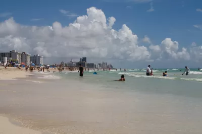
As Hurricane Irma bore down last week, Miami-Dade County Mayor Carlos Gimenez called for a mandatory evacuation of all barrier islands, including Miami Beach, "as well as those living in low-lying areas along the South Miami-Dade coastline," reports Jerry Iannelli for the Miami New Times. The order went into effect on Thursday, September 7.
Barrier islands: no place for development
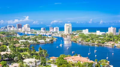
In the U.S., barrier islands exist from Maine to Florida on the Atlantic coast and Florida to Texas on the Gulf Coast. In Florida, Miami Beach is separated from the Miami-Dade County mainland by Biscayne Bay. On its eastern shore is the Atlantic Ocean.
Credit: Google maps
Barrier islands serve a critically important ecological purpose by preventing ocean swells and other storm events from disrupting water systems on their mainland sides, protecting the coastline. "As the first line of defense during storms that threaten coastal communities, barrier islands are very important for reducing the devastating effects of wind and waves and for absorbing storm energy," according to the National Oceanic and Atmospheric Administration (NOAA) of the U.S. Department of Commerce.
A science webpage is even more to the point: "[B]arrier islands are fragile, constantly changing ecosystems that are important for coastal geology and ecology. Development has posed dangers to these ecosystems and has also increased the risk of property damage every year from hurricanes and Nor'easters."
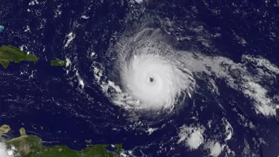
Given barrier islands' critical protective role, should a city of 92,000 people exist on a mile-wide island "averaging only 4.4 feet (1.3 m) above mean sea level hurricane storm surges "could reach 10 feet?"
Sea level rise
Storm surge is not the only environmental problem facing Miami Beach. According to NASA, sea level rise by the end of the century could "range from 0.2 meters to 2.0 meters (0.66 to 6.6 feet)". In South Florida, it could be as much as "two feet over the next four decades," according to Yale Climate Connections.
A history of flooding and destruction
"In the hundred years since [Miami Beach] was incorporated as a city, it has repeatedly been pummeled by major storms, one of which, the Great Hurricane of 1926, wiped out buildings, tossed ships ashore, and remains, in adjusted dollars, the costliest hurricane in American history," wrote David Kamp for Vanity Fair in December 2015. But even on sunny days, high tides can push water up through storm drains and flood city streets.
Those who monitored Hurricane Irma's South Florida approach may have seen interviews of Miami Beach Mayor Phillip Levine, particularly as he implored residents to leave the island. Levine has spearheaded programs to both mitigate flooding and adapt to climate change, wrote Kamp.
Levine models himself after Michael Bloomberg, New York City's mayor from 2002 to 2013—as a first-time officeholder whose wealth and outsider status allow him to bypass an entrenched political culture of intransigence and inaction. After he took office, in November of 2013, Levine fast-tracked a program to install electric pumps along Alton Road and other prime flooding spots on the city’s west side so that, during a storm surge or high tide, the pumps can be switched on, suctioning water off the streets and out into Biscayne Bay.
See Miami Herald video on the pumps (which have their critics) to reduce flooding and roads which have been raised to adapt to sea level rise. Levine and his staff clarified that the pumps will be useless during Irma's storm surge. Their utility will be proven after the surge subsides.
A December 2015 post also distinguished Levine from the state's other leaders, "like Governor Rick Scott and Senator Marco Rubio, who have both proven staunch in opposing [policy] responses to climate change, and to the large-scale interventions that will be necessary for the region to remain habitable in the future."
Of course, Miami Beach doesn't face the perils of sea level rise alone. Shortly after Hurricane Harvey flooded Houston, Oliver Milman, an environment reporter for the Guardian, wrote about how Miami Beach and six other U.S. cities deal with the risk of flooding.
The entire southern section of Florida is at risk from climate change but Miami Beach is eyed with particular concern by other cities. After all, if this wealthy area can't engineer its way out of trouble, where can?
More in Planetizen on South Florida's vulnerability to climate change and sea level rise:
- Miami's Looming Climate Change Disaster, February 24, 2016
-
Diluvial Days Coming to South Florida: Miami Beach is drafting its own textbook for how to respond to sea level rise, December 30, 2015
- Meet the Woman Inspiring Climate Resilience in Miami Beach, June 11, 2015
- Rising Seas Create a Catch-22 for Miami Development, December 31, 2014
- As Seas Rise, Can South Florida Keep its Head Above Water, November 14, 2013
- Climate Adaptation: Is Miami Indefensible?, June 26, 2013
-
Climate Change's Barometer Has No Climate Change Plan (Florida Keys), July 1, 2009
FULL STORY: Miami Beach: Four-foot high Barrier Island Awaits 10 ft. Irma Storm Surge

Florida Prepares for Irma: Building Codes, Cranes, Evacuation, Storm Surge
As Irma leaves the Caribbean and heads for Florida, with landfall expected this weekend, there is a lot to worry about: New building codes will be put to test, fuel to evacuate is in short supply, and cranes have not been dismantled.
Hurricane Ian Puts Renewed Focus on Florida's Barrier Islands
Ian did not impact Southeast Florida, but coastal residents there took notice of the state's deadliest hurricane since 1935 that devastated much of Southwest Florida last month, particularly the barrier islands off the Gulf Coast.
Miami Beach: A Model of Climate Adaptation for Coastal Cities?
How did the seven square mile, four-foot high barrier island in the Atlantic Ocean off Miami and Biscayne Bay hold-up to Hurricane Irma? The city arguably has done more to adapt to sea level rise in recent times than any other coastal city.

Maui's Vacation Rental Debate Turns Ugly
Verbal attacks, misinformation campaigns and fistfights plague a high-stakes debate to convert thousands of vacation rentals into long-term housing.

Planetizen Federal Action Tracker
A weekly monitor of how Trump’s orders and actions are impacting planners and planning in America.

In Urban Planning, AI Prompting Could be the New Design Thinking
Creativity has long been key to great urban design. What if we see AI as our new creative partner?

King County Supportive Housing Program Offers Hope for Unhoused Residents
The county is taking a ‘Housing First’ approach that prioritizes getting people into housing, then offering wraparound supportive services.

Researchers Use AI to Get Clearer Picture of US Housing
Analysts are using artificial intelligence to supercharge their research by allowing them to comb through data faster. Though these AI tools can be error prone, they save time and housing researchers are optimistic about the future.

Making Shared Micromobility More Inclusive
Cities and shared mobility system operators can do more to include people with disabilities in planning and operations, per a new report.
Urban Design for Planners 1: Software Tools
This six-course series explores essential urban design concepts using open source software and equips planners with the tools they need to participate fully in the urban design process.
Planning for Universal Design
Learn the tools for implementing Universal Design in planning regulations.
planning NEXT
Appalachian Highlands Housing Partners
Mpact (founded as Rail~Volution)
City of Camden Redevelopment Agency
City of Astoria
City of Portland
City of Laramie