


Fans of public transit rejoice. A new infographic explores the rolling stock of most of the major cities in the United States and Canada.
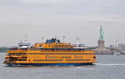
Benjamin Schneider shares news of the City Transit project, the work of public transit aficionado Peter Dovak.
The City Transit infographic offers a "meticulously detailed" illustration of every public transportation mode in 24 major North American cities, like Vancouver, Toronto, and Montreal in Canada, and everything from San Diego to Salt Lake City and the Twin Cities in the United States.
The City Transit project builds on Dovak's earlier effort, published in April 2016, that provided a field guide to all of the Metrobuses in operation in the Washington, D.C. region.
Here, Schneider explains the appeal of Dovak's most recent, geographically broad project:
The most striking thing about the transit vehicle infographics is the sheer variety of vehicle types, including ferries, driverless airport connectors, and several quirky local transit technologies, like Portland’s Aerial Tram, New York City’s Roosevelt Island Tramway, and Los Angeles’ Angel’s Flight, the adorably short funicular featured in La La Land (which will to reopen to the public after Labor Day).
FULL STORY: A Glorious Infographic of North America's Transit Fleets


What $454 Million in Bus Facility Funding Pays for in the United States
Spoiler alert: not much.
Friday Eye Candy: Cities Break Out the Festive Buses for the Holidays
Check out the holiday-themed buses rolling through the Southeastern Pennsylvania Transportation Authority and the Detroit Department of Transportation systems.

Buying American Is Making Infrastructure More Expensive, Study Finds
From train cars to buses, a new study finds that buying American adds cost.

Maui's Vacation Rental Debate Turns Ugly
Verbal attacks, misinformation campaigns and fistfights plague a high-stakes debate to convert thousands of vacation rentals into long-term housing.

Planetizen Federal Action Tracker
A weekly monitor of how Trump’s orders and actions are impacting planners and planning in America.

In Urban Planning, AI Prompting Could be the New Design Thinking
Creativity has long been key to great urban design. What if we see AI as our new creative partner?

King County Supportive Housing Program Offers Hope for Unhoused Residents
The county is taking a ‘Housing First’ approach that prioritizes getting people into housing, then offering wraparound supportive services.

Researchers Use AI to Get Clearer Picture of US Housing
Analysts are using artificial intelligence to supercharge their research by allowing them to comb through data faster. Though these AI tools can be error prone, they save time and housing researchers are optimistic about the future.

Making Shared Micromobility More Inclusive
Cities and shared mobility system operators can do more to include people with disabilities in planning and operations, per a new report.
Urban Design for Planners 1: Software Tools
This six-course series explores essential urban design concepts using open source software and equips planners with the tools they need to participate fully in the urban design process.
Planning for Universal Design
Learn the tools for implementing Universal Design in planning regulations.
planning NEXT
Appalachian Highlands Housing Partners
Mpact (founded as Rail~Volution)
City of Camden Redevelopment Agency
City of Astoria
City of Portland
City of Laramie