


The future of smaller cities could depend on figuring out a way to improve transit, perhaps not at the neighborhood or level, but at the corridor level.
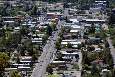
"The state of transit in the US is, generally, pretty damn poor, and this is especially true of smaller cities and towns," writes Sandy Johnston. "Generally, transit in those places is, shall we say, not particularly useful; generally it’s conceived of as a last resort, welfare transit, the kind of thing that only people with no other options use. That’s a product of mentality, but also of lack of resources."
According to Johnston, many older cities, even the smaller ones, have "good bones," and are thus "potentially salvageable as places of good, safe, walkable mixed-use urbanism." The catch, as Johnston describes it, is that there's often only one corridor appropriate for high-frequency transit in small cities, though "the most urban corridor is likely underserved, because of the general terribleness of American transit; but in the smaller cities, this likely means that the city has lost any chance at transit-based urbanism at all." [Emphasis is the author's.]
What follows is "a thought exercise about how small-city transit might look if more funding–or different funding–were available, enough to let agencies focus on intensive service on the best corridors." Johnston also provides some case studies of these concepts: Utica, Binghamton, Kingston, and Glens Falls, and other northeastern and Midwestern cities.
Hat tip to Angie Schmitt for sharing the article.
FULL STORY: Building Urbanism and Transit in Small Cities

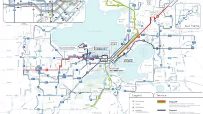
Madison Launches Redesigned Transit System
Transit riders in Madison, Wisconsin are navigating an entirely new system this week.
Americans Continue to Move to Smaller Cities
Cities with populations between 25,000 and 100,000 continue to see an influx of migrants lured by lower costs of living and high quality-of-life metrics.

Australia Planners Want to Ditch the Transit Timetable
The article says the concept of high-frequency transit is popular in Europe and the United States.

Rethinking Redlining
For decades we have blamed 100-year-old maps for the patterns of spatial racial inequity that persist in American cities today. An esteemed researcher says: we’ve got it all wrong.

Planetizen Federal Action Tracker
A weekly monitor of how Trump’s orders and actions are impacting planners and planning in America.

California High-Speed Rail's Plan to Right Itself
The railroad's new CEO thinks he can get the project back on track. The stars will need to align this summer.

Opinion: Make Buses More Like Sidewalks
Sidewalks are an intuitive, low-cost, and easily accessible mobility tool. Can local buses function in the same way?

How Cities Can Support Climate Adaptation
In the face of federal cuts to climate resilience funding, a panel at ULI’s Resilience Summit offered suggestions for maintaining managed retreat and other climate adaptation programs.

Transportation Research Centers Lose Key Federal Funding
The federal University Transportation Center program funds critical transportation research and innovation at 35 consortia of colleges and universities.
Urban Design for Planners 1: Software Tools
This six-course series explores essential urban design concepts using open source software and equips planners with the tools they need to participate fully in the urban design process.
Planning for Universal Design
Learn the tools for implementing Universal Design in planning regulations.
City of Clovis
City of Moorpark
City of Camden Redevelopment Agency
City of Astoria
Transportation Research & Education Center (TREC) at Portland State University
Regional Transportation Commission of Southern Nevada
Toledo-Lucas County Plan Commissions