


Its easy to criticize Florida, one of the deadliest states for pedestrians, however progress is being made through collaborative approaches between local citizens and their municipal officials.
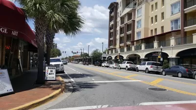
Edgewater Drive formed the main commercial spine for Orlando's College Park neighborhood. However, the roadway was downright deadly—a crash occurred nearly every three days, resulting in injuries every nine days. The ciity of Orlando along with neighborhood stakeholders and the Florida Department of Transportation (FDOT) negotiated plans for a road diet on a 1.5-mile stretch of Edgewater in conjunction with regularly scheduled maintenance to help turn the corridor into a vibrant, pedestrian-oriented commercial district. The results herein have been dramatic.
FULL STORY: Edgewater Drive: A Safer Street through Lane Reduction

SunRail Phase II Receives $93.4 Million FTA Grant
Florida's SunRail commuter rail received a $93.4 grant from the Federal Transit Administration to extend the 61-mile line. The grant will cover half the capital costs for the 17.2-mile extension from Orlando to Osceola County.
Largest TIFIA Loan to P3 Goes to Florida's 'I-4 Ultimate' Project
Transportation Secretary Foxx announced the largest TIFIA loan to be awarded to a public-private partnership will be used to widen 21 miles of Interstate 4 in Florida known as "I-4 Ultimate" by adding four express or toll lanes in the Orlando area.

Nation's Most Dangerous City for Pedestrians Becoming Safer
A Smart Growth America report put the spotlight on Orlando and the entire state of Florida as leading the nation in pedestrian deaths per capita. NPR investigate what is being done to lose the infamous title.

Planetizen Federal Action Tracker
A weekly monitor of how Trump’s orders and actions are impacting planners and planning in America.

Restaurant Patios Were a Pandemic Win — Why Were They so Hard to Keep?
Social distancing requirements and changes in travel patterns prompted cities to pilot new uses for street and sidewalk space. Then it got complicated.

Map: Where Senate Republicans Want to Sell Your Public Lands
For public land advocates, the Senate Republicans’ proposal to sell millions of acres of public land in the West is “the biggest fight of their careers.”

Maui's Vacation Rental Debate Turns Ugly
Verbal attacks, misinformation campaigns and fistfights plague a high-stakes debate to convert thousands of vacation rentals into long-term housing.

San Francisco Suspends Traffic Calming Amidst Record Deaths
Citing “a challenging fiscal landscape,” the city will cease the program on the heels of 42 traffic deaths, including 24 pedestrians.

California Homeless Arrests, Citations Spike After Ruling
An investigation reveals that anti-homeless actions increased up to 500% after Grants Pass v. Johnson — even in cities claiming no policy change.
Urban Design for Planners 1: Software Tools
This six-course series explores essential urban design concepts using open source software and equips planners with the tools they need to participate fully in the urban design process.
Planning for Universal Design
Learn the tools for implementing Universal Design in planning regulations.
Heyer Gruel & Associates PA
JM Goldson LLC
Custer County Colorado
City of Camden Redevelopment Agency
City of Astoria
Transportation Research & Education Center (TREC) at Portland State University
Camden Redevelopment Agency
City of Claremont
Municipality of Princeton (NJ)