


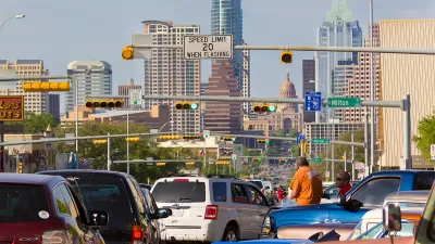
Austin has mostly been planning, designing, and engineering its streets the same way for 20 years. A new Street Design Guide would pave the way for a new era.

Syeda Hasan reports on the new draft of the Austin Street Design Guide [pdf], released earlier this week.
"The guide takes into account some key considerations to try and make Austin streets more uniform and consistent, including the community surrounding a street, the number of lanes and different modes of transportation options, like bikes and public transit," writes Hasan.
"The new guide divides each street into three sections – pedestrian zones, bicycle zones and motor vehicle and transit zones; it recommends dimensions for each of those features. It also categorizes streets by their context, like urban, suburban or industrial," adds Hasan.
The article includes soundbites provided by Annick Beaudet, a manager with the Austin Transportation Department, and Liane Miller, a project manager with the Austin Transportation Department. Both provide insight into how the guide will update the city's existing transportation plan.
Though the city's transportation plan hasn't been updated in 20 years, the city did earn acclaim for its 2014 complete streets policy.
FULL STORY: Austin Unveils New Guide For The Future Of Street Design

Austin Strategic Mobility Plan Final Draft Released
The first priority of the draft Austin Strategic Mobility Plan is to reduce single-occupant vehicle trips.

Catch Up With Austin's CodeNEXT
CodeNEXT is one of the most ambitious, and controversial, zoning reform projects ongoing in the country, with lessons to offer planners all over the country in code writing, public outreach, and planning outcomes.

US Street Design Manual Inches Toward Safer Roads
The guiding document for U.S. road design is starting to recognize the needs of people walking and biking, but safe streets advocates say more significant changes are needed to reduce the high number of pedestrian deaths and improve connectivity for all road users.

Maui's Vacation Rental Debate Turns Ugly
Verbal attacks, misinformation campaigns and fistfights plague a high-stakes debate to convert thousands of vacation rentals into long-term housing.

Planetizen Federal Action Tracker
A weekly monitor of how Trump’s orders and actions are impacting planners and planning in America.

In Urban Planning, AI Prompting Could be the New Design Thinking
Creativity has long been key to great urban design. What if we see AI as our new creative partner?

Florida Seniors Face Rising Homelessness Risk
High housing costs are pushing more seniors, many of them on a fixed income, into homelessness.

Massachusetts Budget Helps Close MBTA Budget Gap
The budget signed by Gov. Maura Healey includes $470 million in MBTA funding for the next fiscal year.

Milwaukee Launches Vision Zero Plan
Seven years after the city signed its Complete Streets Policy, the city is doubling down on its efforts to eliminate traffic deaths.
Urban Design for Planners 1: Software Tools
This six-course series explores essential urban design concepts using open source software and equips planners with the tools they need to participate fully in the urban design process.
Planning for Universal Design
Learn the tools for implementing Universal Design in planning regulations.
Gallatin County Department of Planning & Community Development
Heyer Gruel & Associates PA
JM Goldson LLC
City of Camden Redevelopment Agency
City of Astoria
Transportation Research & Education Center (TREC) at Portland State University
Jefferson Parish Government
Camden Redevelopment Agency
City of Claremont