


A planning consultant hired by FirstEnergy is putting out the first speculative ideas for the future of a contaminated lakefront site of a most demolished power plant.
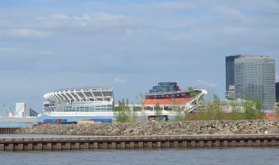
"The contaminated site of the largely demolished FirstEnergy lakefront power plant at East 72nd Street could become a park, or it could host housing, commercial and institutional development, a creative zone for small-scale innovators, or a food production center," reports Steven Litt, sharing the details of a presentation by planning firm CRTKL to the St. Clair Superior Development Corp. in late March.
The recent meeting was the second of the year, "in a fast-moving process" aimed at providing guidance to FirtEnergy and the city for the future of the site. "FirstEnergy is paying for the study to satisfy part of an agreement under which the city allowed it to demolish the former coal-fired plant and to prepare for its eventual sale," reports Litt.
The article includes a lot more detail about the planning study and outreach process so far, the political situation (including the opinions of a group of local advocates called the Green Ribbon Coalition), and the environmental concerns about the site.
FULL STORY: FirstEnergy lakefront site could host parks, housing, gardens and more, planner says

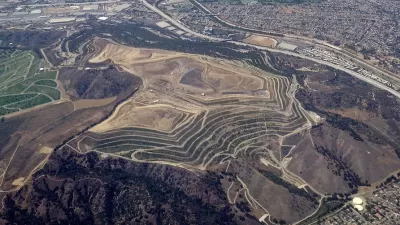
Creating a New Regional Park by Restoring Degraded Lands
Los Angeles County is transforming 142 acres of the Puente Hills Landfill into parkland, creating the first new regional park in the county in over 35 years. The recently released concept plan and renderings show what the park will look like.
6 International Models of Urban Revitalization
The New York Times recently published an article exploring six cities from around the world reinventing themselves for the 21st century: Paris, Sydney, Medellin, Lisbon, Singapore, and Durban.

Urban Rivers Everywhere Follow the Cuyahoga's Lead
On the 50th anniversary of the Cuyahoga River catching fire in Cleveland, it's a good time for urban river keepers everywhere to reevaluate their work and redouble their efforts to make safe and healthy rivers for everyone.

Planetizen Federal Action Tracker
A weekly monitor of how Trump’s orders and actions are impacting planners and planning in America.

Congressman Proposes Bill to Rename DC Metro “Trump Train”
The Make Autorail Great Again Act would withhold federal funding to the system until the Washington Metropolitan Area Transit Authority (WMATA), rebrands as the Washington Metropolitan Authority for Greater Access (WMAGA).

DARTSpace Platform Streamlines Dallas TOD Application Process
The Dallas transit agency hopes a shorter permitting timeline will boost transit-oriented development around rail stations.

San Francisco's School District Spent $105M To Build Affordable Housing for Teachers — And That's Just the Beginning
SFUSD joins a growing list of school districts using their land holdings to address housing affordability challenges faced by their own employees.

Car-Centric LA Suburb Looks to a Train-Oriented Future
City leaders in Rancho Cucamonga, the future western terminus of the Brightline West rail line to Las Vegas, want to reimagine the city as a transit-oriented, pedestrian-friendly community.

New Alaska Bitcoin Mine Would Burn as Much Energy as the State’s Largest Coal Plant
Fueled by “stranded” natural gas, the startup hopes to become the largest in the US, and to make Alaska an industry center.
Urban Design for Planners 1: Software Tools
This six-course series explores essential urban design concepts using open source software and equips planners with the tools they need to participate fully in the urban design process.
Planning for Universal Design
Learn the tools for implementing Universal Design in planning regulations.
Municipality of Princeton
Roanoke Valley-Alleghany Regional Commission
City of Mt Shasta
City of Camden Redevelopment Agency
City of Astoria
Transportation Research & Education Center (TREC) at Portland State University
US High Speed Rail Association
City of Camden Redevelopment Agency
Municipality of Princeton (NJ)