


A new tool from the Department of Transportation maps all the noise created by traffic nationwide.
The first National Transportation Noise Map is part of the DOT's National Transportation Altas Database, and is meant to help agencies and officials implement policies that reduce traffic noise.
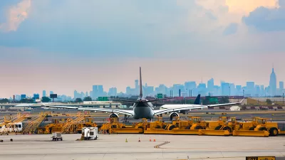
Noise levels are important not only to quality of life, but also to public health, and understanding an area's exposure to noise is part of ensuring safe housing there. People living in cities and near airports are most at risk for noise-induced hearing loss, the Noise Map reveals. The Architect’s Newspaper explains:
Sustained exposure to 85 or more decibels—heavy city traffic—can cause permanent hearing loss over time. In the New York metro area, residents living near the region’s airports or under flight paths are at greatest risk for unhealthy noise exposure.
Most Americans live in areas with safe noise levels: 97 percent hear background noise from highways and planes at about the volume of a humming refrigerator. But approximately 223,000 Americans hear at least 80 or more decibels of heavy traffic or airplane noise regularly.
The data provided by the map could aid efforts to reduce unhealthy noise, like the recently launched project to sound-proof homes on Chicago's South Side.
The Noise Map currently includes data up to 2014 and will be updated annually. Future versions may also include noise from rail roads and ships.
FULL STORY: DOT releases first-ever noise map of the United States


How To Limit Urban Noise
Environmental noise can pose serious health risks ranging from sleep disruptions to higher blood pressure.

Harnessing Data for Community Development
Using data and insights encourages the development of a community, offering an evidence-based strategy to directly address the needs within.
Using Tech to Control Noise Pollution
Several cities are piloting programs that use machine learning to identify and understand urban noise patterns and enforce noise ordinances.

Maui's Vacation Rental Debate Turns Ugly
Verbal attacks, misinformation campaigns and fistfights plague a high-stakes debate to convert thousands of vacation rentals into long-term housing.

Planetizen Federal Action Tracker
A weekly monitor of how Trump’s orders and actions are impacting planners and planning in America.

San Francisco Suspends Traffic Calming Amidst Record Deaths
Citing “a challenging fiscal landscape,” the city will cease the program on the heels of 42 traffic deaths, including 24 pedestrians.

Defunct Pittsburgh Power Plant to Become Residential Tower
A decommissioned steam heat plant will be redeveloped into almost 100 affordable housing units.

Trump Prompts Restructuring of Transportation Research Board in “Unprecedented Overreach”
The TRB has eliminated more than half of its committees including those focused on climate, equity, and cities.

Amtrak Rolls Out New Orleans to Alabama “Mardi Gras” Train
The new service will operate morning and evening departures between Mobile and New Orleans.
Urban Design for Planners 1: Software Tools
This six-course series explores essential urban design concepts using open source software and equips planners with the tools they need to participate fully in the urban design process.
Planning for Universal Design
Learn the tools for implementing Universal Design in planning regulations.
Heyer Gruel & Associates PA
JM Goldson LLC
Custer County Colorado
City of Camden Redevelopment Agency
City of Astoria
Transportation Research & Education Center (TREC) at Portland State University
Jefferson Parish Government
Camden Redevelopment Agency
City of Claremont