


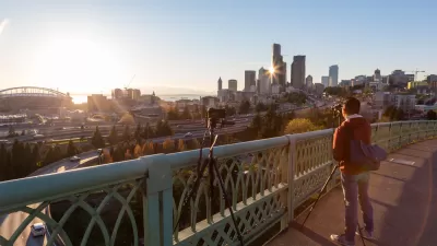
After repainting the lanes on Rainier Avenue in Seattle, the street works better for everyone. If it's that easy, why isn't the model implemented more widely?
"A 2015 safe streets redesign on Rainier Ave is working even better than expected by nearly every measure," according to an article by Tom Fucoloro.
Just by repainting the lines on the major street, the city’s Vision Zero team was able to dramatically reduce the number of dangerous collisions, nearly eliminate high-end speeding, speed up transit, and fully eliminate serious injuries and deaths. Meanwhile, delays for people driving were minimal, clocking in well below pre-construction estimates, according to a new report (PDF).
The article recounts the community-led political effort that produced the changes and also unpacks the data regarding the improvements on the street in a lot more detail.
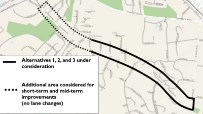
Planetizen picked up on the news about the changes on Rainier Avenue back in January 2016, when the project made news as a solution for Seattle's "most dangerous" street. Part of the reason that the project is back in the news is the Seattle Department of Transportation is starting a public outreach process for a proposed extension of safety project "from the current project boundary south of Hillman City all the way to Rainier Beach."
Hat tip to Streetsblog USA's Twitter feed for the link to the story. Streetsblog USA editor Angie Schmitt added additional commentary on the news about Rainier Avenue's improvements on her Twitter feed, as shown below.
We know how to drastically reduce traffic deaths. We just don't do it https://t.co/ItSritpCwf
— Angie Schmitt (@schmangee) February 24, 2017
FULL STORY: Rainier Ave safety project worked even better than planned, city will extend it south

A Thorough, Mixed Review for a New Protected Bike Lane in Seattle
So many highly anticipated bike facilities finally deliver only to fall short of real game changing status. Seattle provides the latest example of the phenomenon in the wild.
Fixing Seattle's Most Dangerous Road
In-depth coverage of the improvement efforts underway on Seattle's Rainier Avenue.
When it Comes to Road Diets, Evidence Doesn't Matter
Drivers are a powerful enough lobby to overcome all evidence of the need to redesign streets for safety. Examples from Maryland and Virginia provide the latest case studies in Vision Zero futility.

Maui's Vacation Rental Debate Turns Ugly
Verbal attacks, misinformation campaigns and fistfights plague a high-stakes debate to convert thousands of vacation rentals into long-term housing.

Planetizen Federal Action Tracker
A weekly monitor of how Trump’s orders and actions are impacting planners and planning in America.

In Urban Planning, AI Prompting Could be the New Design Thinking
Creativity has long been key to great urban design. What if we see AI as our new creative partner?

King County Supportive Housing Program Offers Hope for Unhoused Residents
The county is taking a ‘Housing First’ approach that prioritizes getting people into housing, then offering wraparound supportive services.

Researchers Use AI to Get Clearer Picture of US Housing
Analysts are using artificial intelligence to supercharge their research by allowing them to comb through data faster. Though these AI tools can be error prone, they save time and housing researchers are optimistic about the future.

Making Shared Micromobility More Inclusive
Cities and shared mobility system operators can do more to include people with disabilities in planning and operations, per a new report.
Urban Design for Planners 1: Software Tools
This six-course series explores essential urban design concepts using open source software and equips planners with the tools they need to participate fully in the urban design process.
Planning for Universal Design
Learn the tools for implementing Universal Design in planning regulations.
planning NEXT
Appalachian Highlands Housing Partners
Mpact (founded as Rail~Volution)
City of Camden Redevelopment Agency
City of Astoria
City of Portland
City of Laramie