


Breezewood Pennsylvania is home to a traffic bottle neck on the I-70, and could be a target of Trump's promised infrastructure spending.
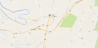
When Interstate 70 passes through Breezewood, Pennsylvania, it starts to look like a plate of spaghetti. There's a two-mile loop through the town that could be eliminated with a simple interchange, but if it were, that would also eliminate a large source of income for the city. The issue has been a source of a lot of frustration, "Many other drivers vent similar — often profane — anger and confusion about this notorious choke point," Charlie Savage Reports for the New York Times.
Savage suggests that eliminating this frustration could be a target for some of the infrastructure budget that the Trump Administration promised during the campaign. "The trucking industry would save as much as 142,362 hours in driver time and $9 million in operating costs every year. Add to that the time and money savings for car drivers, to say nothing of eliminating the unnecessary carbon dioxide emissions from the fuel that both types of vehicles burn to travel the extra distance," Savage writes. There have been many proposals in the past to put in the interchange but past politicians couldn't overcome resistance from the stakeholders that profit from the highway slowdown in the city of Breezewood, whether or not the Trump Administration will take on the challenge is yet to be seen.
FULL STORY: As Trump Vows Building Splurge, Famed Traffic Choke Point Offers Warning

Top Republicans Encourage Governors to Ignore FHWA Guidance
Senators McConnell and Capito reject the administration's efforts to steer federal funds to infrastructure projects that prioritize road maintenance and transit and pedestrian improvements over new road construction.

Opinion: America's Infrastructure Doesn't Need a Federal Spending 'Binge'
Despite alarming claims about the nation's roads and bridges, a column in the Chicago Tribune argues that the administration's proposed infrastructure spending doesn't match actual needs.
$900 Million in BUILD Transportation Grants Announced
The U.S. Department of Transportation this week announced $900 million in BUILD grant funding for transportation projects around the country, supporting a similar focus on rural and highway projects as in previous rounds of spending.

Maui's Vacation Rental Debate Turns Ugly
Verbal attacks, misinformation campaigns and fistfights plague a high-stakes debate to convert thousands of vacation rentals into long-term housing.

Planetizen Federal Action Tracker
A weekly monitor of how Trump’s orders and actions are impacting planners and planning in America.

In Urban Planning, AI Prompting Could be the New Design Thinking
Creativity has long been key to great urban design. What if we see AI as our new creative partner?

King County Supportive Housing Program Offers Hope for Unhoused Residents
The county is taking a ‘Housing First’ approach that prioritizes getting people into housing, then offering wraparound supportive services.

Researchers Use AI to Get Clearer Picture of US Housing
Analysts are using artificial intelligence to supercharge their research by allowing them to comb through data faster. Though these AI tools can be error prone, they save time and housing researchers are optimistic about the future.

Making Shared Micromobility More Inclusive
Cities and shared mobility system operators can do more to include people with disabilities in planning and operations, per a new report.
Urban Design for Planners 1: Software Tools
This six-course series explores essential urban design concepts using open source software and equips planners with the tools they need to participate fully in the urban design process.
Planning for Universal Design
Learn the tools for implementing Universal Design in planning regulations.
planning NEXT
Appalachian Highlands Housing Partners
Mpact (founded as Rail~Volution)
City of Camden Redevelopment Agency
City of Astoria
City of Portland
City of Laramie