


Daniel Kay Hertz argues that, besides improving service, a little signage could save the city of Chicago billions of dollars in service expansion costs.
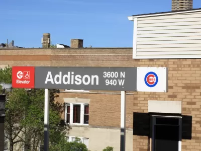
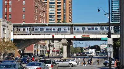
The city of Chicago recently received over a billion dollars in federal funding to expand service to its North Side Red, Brown and Purple Lines, Daniel Kay Hertz argues that "Making all of Chicago’s rail lines clear and viable options for public transit would be equivalent to spending tens of billions of dollars to expand the L," in an article for Chicago Magazine. Simply making signs that direct commuters on the way to get from one train to another could make a huge difference in how people travel through the city. Most commuters in Chicago are only familiar with the transit system, in part because a CTA map only shows the eight trains the CTA controls. "There are actually 20 rail lines that serve Chicago: eight CTA lines, 11 Metra lines, and the South Shore Line, a commuter railroad that runs into northwest Indiana," Daniel Kay Hertz writes in Chicago Magazine.
Chicago Transit organizations exist under the umbrella organization of the RTA which has begun to work toward this goal. "The RTA has created maps that show travelers all of their transit options, regardless of the agency that provides them, and is placing them at 14 more locations around Chicagoland, after beginning with just four in the last few years," Hertz writes. There's no reason that coordination needs to stop at signs, Hertz suggests that Chicago could follow Toronto's example and make their regional trains (a Metra equivalent) run more frequently so that riders could more easily transfer from the CTA.
FULL STORY: These New Transit Signs Could Save Chicago Billions of Dollars

Chicago Transit Increasing Rail Service to Pre-Pandemic Levels
The Chicago Transit Authority is close to returning both rail and bus service to pre-pandemic schedules, with some adjustments for new travel demand.
Chicago Transit Report Calls for Income-Based Fares, Paratransit Funding
An RTA report highlights a need for state funding to bridge an imminent $730 budget shortfall, calling for an approach that relies less heavily on fare revenue.
Chicago Transit Releases 2024 Budget
The agency projects modest ridership growth while aiming to make long-term investments in bus and rail improvements.

Maui's Vacation Rental Debate Turns Ugly
Verbal attacks, misinformation campaigns and fistfights plague a high-stakes debate to convert thousands of vacation rentals into long-term housing.

Planetizen Federal Action Tracker
A weekly monitor of how Trump’s orders and actions are impacting planners and planning in America.

San Francisco Suspends Traffic Calming Amidst Record Deaths
Citing “a challenging fiscal landscape,” the city will cease the program on the heels of 42 traffic deaths, including 24 pedestrians.

Defunct Pittsburgh Power Plant to Become Residential Tower
A decommissioned steam heat plant will be redeveloped into almost 100 affordable housing units.

Trump Prompts Restructuring of Transportation Research Board in “Unprecedented Overreach”
The TRB has eliminated more than half of its committees including those focused on climate, equity, and cities.

Amtrak Rolls Out New Orleans to Alabama “Mardi Gras” Train
The new service will operate morning and evening departures between Mobile and New Orleans.
Urban Design for Planners 1: Software Tools
This six-course series explores essential urban design concepts using open source software and equips planners with the tools they need to participate fully in the urban design process.
Planning for Universal Design
Learn the tools for implementing Universal Design in planning regulations.
Heyer Gruel & Associates PA
JM Goldson LLC
Custer County Colorado
City of Camden Redevelopment Agency
City of Astoria
Transportation Research & Education Center (TREC) at Portland State University
Jefferson Parish Government
Camden Redevelopment Agency
City of Claremont