


The cities of West Sacramento and Sacramento have high hopes for a streetcar line planned for some of the most beautiful and urban neighborhoods in the region. The Trump Administration could still change the course of the project, however.
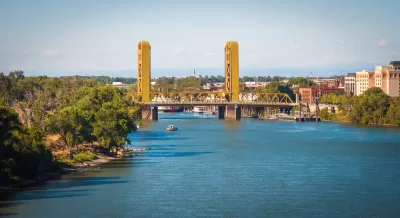
The Sacramento Bee presents a graphic by Sharon Okada, with reporting from Tony Bizjak and Ryan Lillis, on plans in Sacramento and West Sacramento "to build a 4.2-mile streetcar line on city streets, stopping near major landmarks."
The interactive graphic provides a look at 9 points along the streetcar route, including it's first stop in West Sacramento, past Raley Field (home of the Sacramento River Cats, the AAA affiliate of the San Francisco Giants), over the Tower Bridge (pictured above), past Old Town and the site of the under-construction NBA arena, and through to the Capitol Building and the Convention Center—before looping back from whence it came.
In a separate article, Tony Bizjak reports on the possible effects of Trump Administration policies on the funding and delivery of the $150 million project. The city hopes to break ground on the project in 2018, but that plan would require the city to come up with matching local funds for $75 million promised by the Obama Administration. "This year, proponents say they plan to amend that request, asking the Federal Transit Administration to up its contribution to $100 million for a bigger $200 million project," adds Bizjak.
FULL STORY: Take a tour of Sacramento’s proposed streetcar route


Business Owners Vote to Fund Sacramento Streetcar Operations
The two-thirds threshold proved to be no obstacle for Sacramento streetcar proponents in a special election held June 21, when at least *250 businesses owners voted to tax themselves to fund operations of the proposed streetcar.
Big Payoff for Transit from California Cap-and-Trade Program
The future of cap-and-trade in California may be uncertain, but the $391 million allocated Tuesday from the program for greenhouse gas-reducing transit capital projects is real. A plan to release $1.2 billion of carbon revenue has been introduced.
Sacramento Streetcar Funding Reaches Key Goal
Imagine taking a streetcar across Sacramento's iconic Tower Bridge for a three mile trip. Backers are en route to securing matching local funding for the project. However, local voters will have the final say in a June 2 Mello-Roos special election.

Maui's Vacation Rental Debate Turns Ugly
Verbal attacks, misinformation campaigns and fistfights plague a high-stakes debate to convert thousands of vacation rentals into long-term housing.

Planetizen Federal Action Tracker
A weekly monitor of how Trump’s orders and actions are impacting planners and planning in America.

San Francisco Suspends Traffic Calming Amidst Record Deaths
Citing “a challenging fiscal landscape,” the city will cease the program on the heels of 42 traffic deaths, including 24 pedestrians.

Defunct Pittsburgh Power Plant to Become Residential Tower
A decommissioned steam heat plant will be redeveloped into almost 100 affordable housing units.

Trump Prompts Restructuring of Transportation Research Board in “Unprecedented Overreach”
The TRB has eliminated more than half of its committees including those focused on climate, equity, and cities.

Amtrak Rolls Out New Orleans to Alabama “Mardi Gras” Train
The new service will operate morning and evening departures between Mobile and New Orleans.
Urban Design for Planners 1: Software Tools
This six-course series explores essential urban design concepts using open source software and equips planners with the tools they need to participate fully in the urban design process.
Planning for Universal Design
Learn the tools for implementing Universal Design in planning regulations.
Heyer Gruel & Associates PA
JM Goldson LLC
Custer County Colorado
City of Camden Redevelopment Agency
City of Astoria
Transportation Research & Education Center (TREC) at Portland State University
Jefferson Parish Government
Camden Redevelopment Agency
City of Claremont