


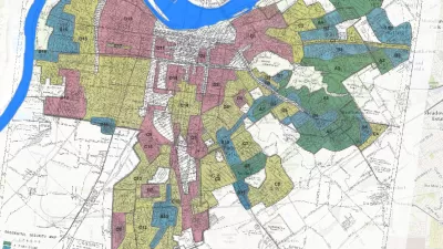
The Mapping Inequality website documents how the liberal ideals of the New Deal devolved into discrimination and inequality.
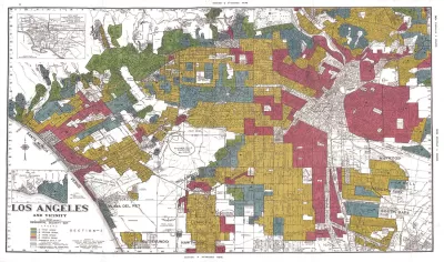
"The maps in this post are part of a grim history," according to an article by Greg Miller. "They were created by a government program in the 1930s and played a role in keeping African Americans and other minorities from owning property in American cities, thereby leaving an indelible mark on the racial and economic history of the United States."
The Mapping Inequality project has gathered these maps and documents, the work of the Home Owners' Loan Corporation (HOLC) during the Great Depression, and placed them online.
Miller explains more of the redlining history of the HOLC, while also sampling specific case studies from cities included in the Mapping Inequality archive—cities such as Los Angeles, Seattle, Wichita, and Portland.
As acknowledged on the Mapping Inequality website, the project combines the work of researchers and students at the University of Richmond, the University of Maryland, Virginia Tech, and Johns Hopkins University.
FULL STORY: Newly Released Maps Show How Housing Discrimination Happened


Reporters Go Undercover to Identify Housing Discrimination
A three-year investigation of the real estate industry on Long Island reveals rampant discriminatory practices and an industry complicit in the segregation of the communities that comprise the region.
Study: Historical Redlining Maps No Longer a Proxy for Black America
Black Americans have moved on from formerly redlined neighborhoods, and other minorities and whites have moved in. The wave of presidential campaigns that have based housing policy proposals on redlining maps might be misguided as a result.

Seattle Exhibit Grapples With Redlining Past and Present
A creative exhibit highlights how redlining and racist exclusion persist today.

Planetizen Federal Action Tracker
A weekly monitor of how Trump’s orders and actions are impacting planners and planning in America.

Maui's Vacation Rental Debate Turns Ugly
Verbal attacks, misinformation campaigns and fistfights plague a high-stakes debate to convert thousands of vacation rentals into long-term housing.

San Francisco Suspends Traffic Calming Amidst Record Deaths
Citing “a challenging fiscal landscape,” the city will cease the program on the heels of 42 traffic deaths, including 24 pedestrians.

Defunct Pittsburgh Power Plant to Become Residential Tower
A decommissioned steam heat plant will be redeveloped into almost 100 affordable housing units.

Trump Prompts Restructuring of Transportation Research Board in “Unprecedented Overreach”
The TRB has eliminated more than half of its committees including those focused on climate, equity, and cities.

Amtrak Rolls Out New Orleans to Alabama “Mardi Gras” Train
The new service will operate morning and evening departures between Mobile and New Orleans.
Urban Design for Planners 1: Software Tools
This six-course series explores essential urban design concepts using open source software and equips planners with the tools they need to participate fully in the urban design process.
Planning for Universal Design
Learn the tools for implementing Universal Design in planning regulations.
Heyer Gruel & Associates PA
JM Goldson LLC
Custer County Colorado
City of Camden Redevelopment Agency
City of Astoria
Transportation Research & Education Center (TREC) at Portland State University
Jefferson Parish Government
Camden Redevelopment Agency
City of Claremont