


Imagine a built environment that starts from a central location of Scottsdale, Arizona, sprawling outwards until it covers 70 percent of all land on Earth.
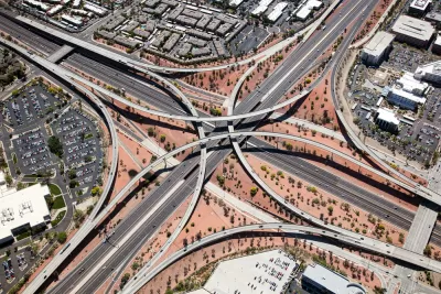
"Forecasting the continued rapid growth of the metropolitan area in the coming decades, a study published Thursday by researchers at Syracuse University has found that the majority of Earth’s landmass will be Phoenix suburbs by 2050."
The scale of such a prediction could only be the work of satire, which is the bread and butter of the website The Onion.
Yes, this is not a real news story, and there is no such study.
The study's fake authors, however, do seem well aware of the realities of transportation in such an inefficient land use scenario:
The researchers warned, however, that a lack of adequate transportation infrastructure in the Phoenix metro area could create problems for workers driving in from the suburbs, estimating that traffic congestion during rush hour could add as much as 1,200 to 1,400 hours to their daily commutes.
FULL STORY: New Study Finds Most Of Earth’s Landmass Will Be Phoenix Suburb By 2050

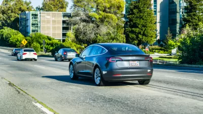
Friday Funny: Tesla Invents the Greenest Car
The Fake News website The Onion reports a complete fabrication about Elon Musk and Tesla.
Friday Funny: Nation in Rapture Over Construction Project
Reading The Onion's latest satire of the built environment is a bit like the experience it describes: watching as a crane moves a large object on a construction site, otherwise known as being easily distracted by harmless fun.
Friday Funny? The Onion Imagines the Future of the Hit and Run
Satire is supposed to make us uncomfortable. A recent totally fake news report imagining hit-and-run technology for self-driving cars (called the "Culpability-Evasion System") definitely succeeded there.

Planetizen Federal Action Tracker
A weekly monitor of how Trump’s orders and actions are impacting planners and planning in America.

Restaurant Patios Were a Pandemic Win — Why Were They so Hard to Keep?
Social distancing requirements and changes in travel patterns prompted cities to pilot new uses for street and sidewalk space. Then it got complicated.

Map: Where Senate Republicans Want to Sell Your Public Lands
For public land advocates, the Senate Republicans’ proposal to sell millions of acres of public land in the West is “the biggest fight of their careers.”

Maui's Vacation Rental Debate Turns Ugly
Verbal attacks, misinformation campaigns and fistfights plague a high-stakes debate to convert thousands of vacation rentals into long-term housing.

San Francisco Suspends Traffic Calming Amidst Record Deaths
Citing “a challenging fiscal landscape,” the city will cease the program on the heels of 42 traffic deaths, including 24 pedestrians.

California Homeless Arrests, Citations Spike After Ruling
An investigation reveals that anti-homeless actions increased up to 500% after Grants Pass v. Johnson — even in cities claiming no policy change.
Urban Design for Planners 1: Software Tools
This six-course series explores essential urban design concepts using open source software and equips planners with the tools they need to participate fully in the urban design process.
Planning for Universal Design
Learn the tools for implementing Universal Design in planning regulations.
Heyer Gruel & Associates PA
JM Goldson LLC
Custer County Colorado
City of Camden Redevelopment Agency
City of Astoria
Transportation Research & Education Center (TREC) at Portland State University
Camden Redevelopment Agency
City of Claremont
Municipality of Princeton (NJ)