


"Strategic retreat" as a response to rising sea levels isn't an easy sell, but a new report endeavors to make the idea more palatable.
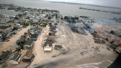
The Lincoln Institute of Land Policy and the Regional Plan Association make the case for managed retreat from flood zones with new research into the use of buyouts. The report, Buy-In for Buyouts: The Case for Managed Retreat from Flood Zones, focuses especially on building support for buyouts among local governments and community members.
The fiscal impact of buyout programs is one of the biggest factors weighed by local governments in embracing or resisting buyout programs, according to the report. Incorporating financial considerations into the reuse of acquired properties and the relocation of residents is critical. For example, well designed parks can make nearby property more desirable, and open space projects can deliver water supply and flood prevention benefits, thereby increasing land values.
Though the Federal Emergency Management Agency (FEMA) and the U.S. Department of Housing and Urban Development (HUD) fund buy-out programs, such programs are usually managed and overseen locally, meaning they play out differently depending on the community. The post includes five recommendations for flood-prone communities, as described in the report.
FULL STORY: The Case for Managed Retreat from Flood Zones

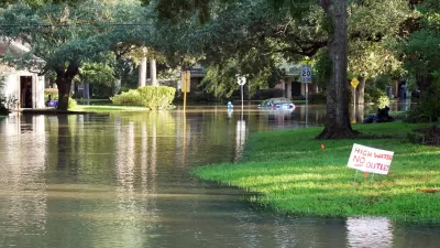
Severe Flooding Calls Attention to Houston’s Home Buyout Struggles
Recent extreme flooding along the San Jacinto River has prompted a review of the progress of Harris County’s flood-prone home buyout program.
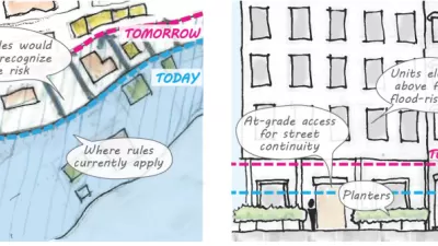
'Zoning for Coastal Flood Resiliency' Wins Planning Commission Approval in NYC
Emergency responses to Hurricane Sandy have turned into long-term lessons in New York City, as the nation's largest city crafts a response to sea-level rise and extreme weather by making changes to the zoning code of coastal areas.
Proposed Citywide Rezoning Would Layer Resilience in New York City
With 520 miles of coastline, New York City is ready to implement the lessons of Hurricane Sandy in the zoning code for the entire city.

Montreal Mall to Become 6,000 Housing Units
Place Versailles will be transformed into a mixed-use complex over the next 25 years.

Planetizen Federal Action Tracker
A weekly monitor of how Trump’s orders and actions are impacting planners and planning in America.

DARTSpace Platform Streamlines Dallas TOD Application Process
The Dallas transit agency hopes a shorter permitting timeline will boost transit-oriented development around rail stations.

Without International Immigrants, the Rural US Population Would Be Falling 58%
Census data shows that population growth in rural areas is due in large part to international migrants.

Dead End: Nine Highways Ready for Retirement
The Freeways Without Futures report describes the nation’s most promising highway removal proposals.

Congressman Proposes Bill to Rename DC Metro “Trump Train”
The Make Autorail Great Again Act would withhold federal funding to the system until the Washington Metropolitan Area Transit Authority (WMATA), rebrands as the Washington Metropolitan Authority for Greater Access (WMAGA).
Urban Design for Planners 1: Software Tools
This six-course series explores essential urban design concepts using open source software and equips planners with the tools they need to participate fully in the urban design process.
Planning for Universal Design
Learn the tools for implementing Universal Design in planning regulations.
City of Mt Shasta
City of Camden Redevelopment Agency
City of Astoria
Transportation Research & Education Center (TREC) at Portland State University
City of Camden Redevelopment Agency
Municipality of Princeton (NJ)
Regional Transportation Commission of Southern Nevada