


Georgetown's grid of small blocks is starkly different from the L'Enfant-designed city that surrounds it.
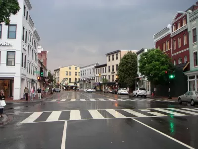
The origins of Washington, D.C.'s Georgetown neighborhood can be traced back to a Scottish man named Ninian Beall, who had the original grant for the land where the neighborhood would develop from a tobacco inspection station to a busy commercial port. Writing in Greater Greater Washington, Topher Mathews traces the history of the neighborhood to its eventual development into a grid comprised of small blocks.
The layout of Georgetown was a typical modest colonial town. The 80 lots were separated by only two streets and two narrow lanes. In the 1780s, several additions were annexed to the town.
...
While the physical structures hadn't filled in the street grid by the 1790s, Pierre L'Enfant nonetheless concluded that Georgetown was too developed with its own town plan to be incorporated into his Baroque plan for the city of Washington.
This design independence has survived to the present day as Georgetown lacks the circles and radials of the rest of downtown Washington.
Matthews notes that while Georgetown's original grid layout survived, many of its street names did not. As Washington, D.C. grew around it and eventually merged with it in 1872, many of the original street names were changed to match the D.C. street system.
FULL STORY: The story behind Georgetown's street grid


Is Washington D.C. Preserving Buildings or Hoarding Them?
A piecemeal, reactive approach to historic preservation in the capital may burden the future with too many buildings of "middling merit."
Georgetown-Rosslyn Gondola Proposal Gets a Funded Study
The idea of a gondola crossing the Potomac might still seem a little pie in the sky, but it has legs.
A New Future Proposed for Georgetown
After announcing its Georgetown 2028 Plan last year, the Georgetown Business Improvement District is continuing its ambitious efforts to bring new facilities and amenities online in Georgetown.

Planetizen Federal Action Tracker
A weekly monitor of how Trump’s orders and actions are impacting planners and planning in America.

The Simple Legislative Tool Transforming Vacant Downtowns
In California, Michigan and Georgia, an easy win is bringing dollars — and delight — back to city centers.

San Francisco's School District Spent $105M To Build Affordable Housing for Teachers — And That's Just the Beginning
SFUSD joins a growing list of school districts using their land holdings to address housing affordability challenges faced by their own employees.

In More Metros Than You’d Think, Suburbs are Now More Expensive Than the City
If you're moving to the burbs to save on square footage, data shows you should think again.

The States Losing Rural Delivery Rooms at an Alarming Pace
In some states, as few as 9% of rural hospitals still deliver babies. As a result, rising pre-term births, no adequate pre-term care and "harrowing" close calls are a growing reality.

The Small South Asian Republic Going all in on EVs
Thanks to one simple policy change less than five years ago, 65% of new cars in this Himalayan country are now electric.
Urban Design for Planners 1: Software Tools
This six-course series explores essential urban design concepts using open source software and equips planners with the tools they need to participate fully in the urban design process.
Planning for Universal Design
Learn the tools for implementing Universal Design in planning regulations.
Smith Gee Studio
City of Charlotte
City of Camden Redevelopment Agency
City of Astoria
Transportation Research & Education Center (TREC) at Portland State University
US High Speed Rail Association
City of Camden Redevelopment Agency
Municipality of Princeton (NJ)