


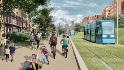
The first phase of the Atlanta Streetcar is open to the public, though the city has big plans to extend the line. One planning academic hopes to redirect the planning process.
Mike Dobbins, professor of the practice of planning at Georgia Tech’s College of Architecture and a former commissioner of planning and community development for the city of Atlanta, reviews the planning and political decisions behind the Atlanta Streetcar. In December, the Atlanta City Council approved an extension of the existing streetcar route, including 22 miles of streetcar track running alongside the BeltLine.
Dobbins's review is a critical one, summarized by the following: "While the old railroad segments that make up the BeltLine make a lot of sense for a park and trail system, they are not a solution for the city’s transit problems…" After laying out what a comprehensive transit planning exercise would look like, Dobbins makes the following recommendation:
While a lot of time, money, and effort has gone into trying to make the “solution” fit the problem, with a successful referendum it is not too late to redirect the city’s efforts to catch up with commonsense transit planning. The Legislature last month enabled Atlanta to put forward a referendum in November 2016 or 2017 for a proposed half-percent increase in the city’s sales tax to raise $2.5 billion for transit construction.
According to Dobbins, reborn legislation that would allow Atlanta voters to decide on a half-cent transit tax offers a new chance to start holistic transit planning process.
FULL STORY: Transit Planning 101 for the City of Atlanta: It’s not too late

Atlanta Streetcar Expansion Still Moving Forward
MARTA has drastically reduced its plans to construct new rail transit, but one project still has political support from the top at City Hall.

Op-Ed: To Meet BeltLine's Affordable Housing Goals, Cut the Streetcar Plans
According to one argument, the importance of developing affordable housing is a higher priority for the Atlanta BeltLine than a streetcar. It's a question of scarce funding, and how to spend it to the greatest public benefit.

On Atlanta's BeltLine and 21st-Century Infrastructure
In an interview, Atlanta BeltLine visionary Ryan Gravel discusses the ongoing project and how it fits an emerging, multidisciplinary understanding of what good infrastructure can be.

Rethinking Redlining
For decades we have blamed 100-year-old maps for the patterns of spatial racial inequity that persist in American cities today. An esteemed researcher says: we’ve got it all wrong.

Planetizen Federal Action Tracker
A weekly monitor of how Trump’s orders and actions are impacting planners and planning in America.

Walmart Announces Nationwide EV Charging Network
The company plans to install electric car chargers at most of its stores by 2030.

Seattle’s Pike Place Market Leans Into Pedestrian Infrastructure
After decades of debate, the market is testing a car ban in one of its busiest areas and adding walking links to the surrounding neighborhood.

The World’s Longest Light Rail Line is in… Los Angeles?
In a city not known for its public transit, the 48.5-mile A Line is the longest of its kind on the planet.

Quantifying Social Infrastructure
New developments have clear rules for ensuring surrounding roads, water, and sewers can handle new users. Why not do the same for community amenities?
Urban Design for Planners 1: Software Tools
This six-course series explores essential urban design concepts using open source software and equips planners with the tools they need to participate fully in the urban design process.
Planning for Universal Design
Learn the tools for implementing Universal Design in planning regulations.
City of Moorpark
City of Tustin
City of Camden Redevelopment Agency
City of Astoria
Transportation Research & Education Center (TREC) at Portland State University
Regional Transportation Commission of Southern Nevada
Toledo-Lucas County Plan Commissions