


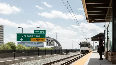
The Denver City Council approved, with a 13-0 vote, the I-25 and Broadway Station Area Plan.
"A transit station area plan that envisions a dense, walkable urban neighborhood at Interstate 25 and Broadway won unanimous approval Monday night from the Denver City Council," reports Jon Murray.
Councilmembers spoke of the desire for the I-25 and Broadway Station Area Plan to create a "Midtown Denver" neighborhood. Several development proposals are already under consideration for the area, and rapid change is expected in the area.
Murray provides additional details about the components of the plan:
Among its major themes: maximum building heights ranging from five to 16 stories, which likely will be limited further by city restrictions on blocking mountain views from Washington Park to the east; a series of "transformative" bridge and pedestrian-oriented projects aimed at connecting neighborhoods and parks across the South Platte River and the railroad tracks; a pedestrian-friendly "shared street" parallel to Broadway, running south from the station; and a grand public plaza near the light-rail platform.
Controversy struck the plan in March over the issue of parking.
FULL STORY: Plan to build vibrant urban district in Denver's I-25/Broadway area wins council approval

A Planning Controversy of the Transit Oriented Variety in Suburban Denver
A controversy has erupted over a proposed vision for transit oriented mixed in a Denver suburb.
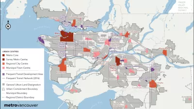
Vancouver Approves New Metro 2050 Regional Plan
The region around Vancouver in British Columbia has a new 30-year regional plan.

New Plans for Transit Oriented Development in South Central L.A.
Los Angeles County recently adopted the Florence-Firestone Transit Oriented District Specific Plan.

Planetizen Federal Action Tracker
A weekly monitor of how Trump’s orders and actions are impacting planners and planning in America.

Restaurant Patios Were a Pandemic Win — Why Were They so Hard to Keep?
Social distancing requirements and changes in travel patterns prompted cities to pilot new uses for street and sidewalk space. Then it got complicated.

Maui's Vacation Rental Debate Turns Ugly
Verbal attacks, misinformation campaigns and fistfights plague a high-stakes debate to convert thousands of vacation rentals into long-term housing.

In California Battle of Housing vs. Environment, Housing Just Won
A new state law significantly limits the power of CEQA, an environmental review law that served as a powerful tool for blocking new development.

Boulder Eliminates Parking Minimums Citywide
Officials estimate the cost of building a single underground parking space at up to $100,000.

Orange County, Florida Adopts Largest US “Sprawl Repair” Code
The ‘Orange Code’ seeks to rectify decades of sprawl-inducing, car-oriented development.
Urban Design for Planners 1: Software Tools
This six-course series explores essential urban design concepts using open source software and equips planners with the tools they need to participate fully in the urban design process.
Planning for Universal Design
Learn the tools for implementing Universal Design in planning regulations.
Heyer Gruel & Associates PA
JM Goldson LLC
Custer County Colorado
City of Camden Redevelopment Agency
City of Astoria
Transportation Research & Education Center (TREC) at Portland State University
Camden Redevelopment Agency
City of Claremont
Municipality of Princeton (NJ)