


The new Transit Explorer tool offers a new way to visualize the scale of the country's transit infrastructure investments. Spoiler alert: 2016 will be a big year.
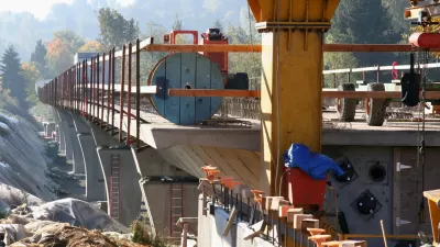
Yonah Freemark of The Transport Politic has released a new tool for visualizing the progress and promise of transit projects around the country. The value of Transit Explorer, as the new tool is called, is on display in a recent blog post by Freemark that performs an inventory of the transit openings and construction starts planned for 2016.
Freemark sums up the evidence visible on Transit Explorer:
"Cities across the country are waking up to new bus and rail lines in droves. In 2016, North American transit agencies are expected to open 245 miles of new fixed-guideway transit lines, including 89 miles of bus rapid transit, 93 miles of commuter rail, 7 miles of heavy rail, 39 miles of light rail, and 18 miles of streetcars. This is more than triple the new mileage of such lines opened in 2015."
Freemark has been doing inventories of expected transit projects since 2009, but this is the first time the effort is supplemented by Transit Explorer. The article also includes a lot of political context on the "long road to 2016" that enabled all of these projects. Freemark is offering a big, ambitious effort to make sense of the country's progress in transit.
FULL STORY: Openings and Construction Starts Planned for 2016


Transit Projects to Watch in 2015
The Transport Politic provides its seventh annual list of major transit investments, finding an enormous amount of effort and funds going into improving transportation systems around North America.
Ranking the Sustainability of Transportation Systems in North American Cities
Out of 23 cities, New York City came in first, Indianapolis came in 23rd.

Today: BART Goes Farther South Than Ever Before
As it has promised for years, Bay Area Rapid Transit today opens the Warm Springs/South Fremont extension of the regional rail transit system. The first train departs at the station at 5:48 am, and the first train arrives at 7:04 am.

Maui's Vacation Rental Debate Turns Ugly
Verbal attacks, misinformation campaigns and fistfights plague a high-stakes debate to convert thousands of vacation rentals into long-term housing.

Planetizen Federal Action Tracker
A weekly monitor of how Trump’s orders and actions are impacting planners and planning in America.

San Francisco Suspends Traffic Calming Amidst Record Deaths
Citing “a challenging fiscal landscape,” the city will cease the program on the heels of 42 traffic deaths, including 24 pedestrians.

Adaptive Reuse Will Create Housing in a Suburban Texas Strip Mall
A developer is reimagining a strip mall property as a mixed-use complex with housing and retail.

Study: Anti-Homelessness Laws Don’t Work
Research shows that punitive measures that criminalized unhoused people don’t help reduce homelessness.

In U.S., Urban Gondolas Face Uphill Battle
Cities in Latin America and Europe have embraced aerial transitways — AKA gondolas — as sustainable, convenient urban transport, especially in tricky geographies. American cities have yet to catch up.
Urban Design for Planners 1: Software Tools
This six-course series explores essential urban design concepts using open source software and equips planners with the tools they need to participate fully in the urban design process.
Planning for Universal Design
Learn the tools for implementing Universal Design in planning regulations.
Heyer Gruel & Associates PA
JM Goldson LLC
Custer County Colorado
City of Camden Redevelopment Agency
City of Astoria
Transportation Research & Education Center (TREC) at Portland State University
Jefferson Parish Government
Camden Redevelopment Agency
City of Claremont