


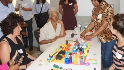
The process of building tactile models of neighborhoods as tools for planning outreach just got an upgrade with a high-tech, interactive Lego model built for the Boston area.
"MIT researchers unveiled something earlier this month that will please toddlers and serious urban planners alike," reports Linda Poon. "It’s a model of Dudley Square—a neighborhood in the greater Boston area—about the size of a kitchen table. The roads, sidewalks, bus stations, and buildings are all made out of Lego blocks. Wee Lego figures represent pedestrians. Laid over it all is a computer-generated projection of the actual neighborhood, filling in the details of current green space and traffic in Dudley Square."
The model is a collaborative project between the MIT Department of Urban Studies and Planning, the Changing Places group at the MIT Media Lab, and the Barr Foundation, according to Poon, designed to test ideas for a bus rapid transit system in the city.
The Lego model is only one of three interactive components, each at different scales, to the project. Also included are a second 3-D model, also made of Legos, of a Boston street, "and a touchscreen interface to illustrate the potential effects of different plans on a regional scale—such as how changes to public transit might affect people’s access to jobs."
Moving the Lego pieces around on the models produces feedback about how those changes would play out through the system.
FULL STORY: Using Legos as a Legitimate Urban Planning Tool

Empowered Through Design: How a Purposefully Rudimentary Activity Sparks the Imagination
Memory can be an intensely powerful tool when planning for the future.
Why Aren’t There More Planners?
Planning can be a great career for socially conscious individuals, but university programs are struggling to attract new students to the field. A trio of academics are raising awareness about the field through community activation.

New Public Hearing Requirements Delay Completion of Reston’s New Comprehensive Plan
One of the country’s most prominent master-planned communities has spent several years working on an a comprehensive plan update. The plan will have to wait a little longer as the Fairfax County, Virginia community adjusts to new state laws.

Planetizen Federal Action Tracker
A weekly monitor of how Trump’s orders and actions are impacting planners and planning in America.

San Francisco's School District Spent $105M To Build Affordable Housing for Teachers — And That's Just the Beginning
SFUSD joins a growing list of school districts using their land holdings to address housing affordability challenges faced by their own employees.

The Tiny, Adorable $7,000 Car Turning Japan Onto EVs
The single seat Mibot charges from a regular plug as quickly as an iPad, and is about half the price of an average EV.

Seattle's Plan for Adopting Driverless Cars
Equity, safety, accessibility and affordability are front of mind as the city prepares for robotaxis and other autonomous vehicles.

As Trump Phases Out FEMA, Is It Time to Flee the Floodplains?
With less federal funding available for disaster relief efforts, the need to relocate at-risk communities is more urgent than ever.

With Protected Lanes, 460% More People Commute by Bike
For those needing more ammo, more data proving what we already knew is here.
Urban Design for Planners 1: Software Tools
This six-course series explores essential urban design concepts using open source software and equips planners with the tools they need to participate fully in the urban design process.
Planning for Universal Design
Learn the tools for implementing Universal Design in planning regulations.
Smith Gee Studio
City of Charlotte
City of Camden Redevelopment Agency
City of Astoria
Transportation Research & Education Center (TREC) at Portland State University
US High Speed Rail Association
City of Camden Redevelopment Agency
Municipality of Princeton (NJ)