The tragedy on Livingston Avenue could have been avoided, but the city of New Brunswick's concern was with motorists—not pedestrians.


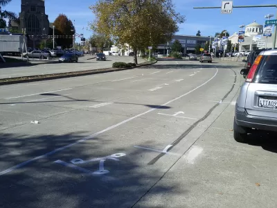
A new study finds that metro areas can reduce traffic crashes by 19 percent on busy arterial streets by imposing a road diet. A road diet reduces the number of lanes dedicated to car traffic, widening the space (and hence improving safety) for cyclists, pedestrians, and street parking. It is an antidote to the previously popular policy of widening arterial roads to accommodate increasing numbers of commuters.
"The original thinking held that wider roads meant better traffic flows, especially at rush-hour, but new lanes also attracted new traffic, and outside the peak periods you'd end up with lots of wasted road space," writes Eric Jaffe.
The case study is a cost-benefit analysis of Livingston Ave in New Brunswick, N.J., "an oversized arterial corridor accessing the center of the city." It comes on the heels of a traffic collision involving three students, who were seriously injured as a result. New Brunswick is home to Rutgers University, and the four-lane street has thousands of rush-hour commuters as well as many pedestrians. Drivers mostly ignore the 25 mph speed limit.
"What makes the situation in New Brunswick so much more regrettable is that city leaders knew about the safety hazards on Livingston Avenue but hesitated to change traffic patterns for fear of offending drivers," Jaffe laments.
Jaffe provides a nice graphic illustrating the simple and cheap road diet alterations proposed. According to the study, the costs are mostly political; research demonstrated that the level of service for drivers increased only modestly after a road diet. Jaffe finds: "All told, the traffic impacts amounted to two or three minutes of total delay and maybe one or two more minutes of travel time, depending on morning or evening rush hour and the precise configuration of the road diet[.]"
Read the full story: The Benefits of Slower Traffic, Measured in Money and Lives

Houston's pedestrian promenade on track to be ready for World Cup crowds
The city is transforming seven downtown blocks along a light rail line into a car-free zone focused on outdoor dining and entertainment.
Rick Steves on Walkability Lessons From Europe
Many of Europe’s pedestrian-friendly, transit-rich cities weren’t always that way.
What Will Become of Fifth Avenue?
Visitors to the iconic shopping street overwhelmingly arrive by walking, transit, or bike. Why are bike and pedestrian infrastructure improvement lagging so far behind another famous NYC street, Broadway?

Planetizen Federal Action Tracker
A weekly monitor of how Trump’s orders and actions are impacting planners and planning in America.

California plans to bury El Niño’s downpour
If the state plays its cards right, it may be able to store a billion acre-feet of El Niño’s water in aquifers.

Chicago breaks ground on $3 billion megadevelopment
The new neighborhood, titled Foundry Park, will one day host 3,700 residences.

California High-Speed Rail Authority CEO resigns after $600,000 scandal
Under Ian Choudri, the authority used taxpayer dollars to fund first class flights and trips to nightclubs.

Want to study the Missouri River? Soon, you may need unanimous approval from 10 states
Legislation would require 10 governors’ permission to study or build projects moving water outside the basin.

Desperate measures: Advocates weigh draining Lake Powell to fill Colorado River
Draining the reservoir could reduce evaporation losses by a couple hundred thousand acre-feet.

FREE Course: Walkable City 1: Why Walkability?
After describing his path towards focusing on walkability as the essence of good planning, Jeff Speck marches through his five principal reasons for making more walkable places.
Reinventing Malls: Planning Alchemy—Turning Gray Fields Into Gold
The course focuses on the opportunities and imperatives that shape reinvention of mall sites.

City of Rosemead
Rutgers University, Edward J. Bloustein School of Planning and Public Policy
One Hundred Miles
Hunter College, City University of New York (CUNY)
The Architects Foundation
University of Cincinnati Online
City of Cambridge
Montrose County
The Pocatello Development Authority